From Kaohsiung, further south to Fangliao. [Wow, the ocean! The sea really is something special.] After about ten days on the island nation of Taiwan, I finally got to see the ocean. From here on, I’ll be running along the coastline.
Even in the plains stretching across western Taiwan, mountains loom close on the left by this point. The railway also ends here at Fangliao. Back then, the railway encircling Taiwan wasn’t yet connected; the eastern Pacific coast line only reached Taitung.
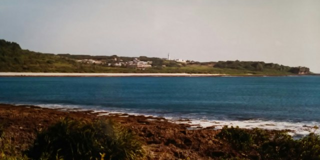
Amidst scattered settlements, about 50 kilometers from Fangliao, I arrived at the resort area of Kenting National Park. Passing through the street where shops and hotels are concentrated, a 30-minute drive brings you to the southernmost point of Taiwan, the cape of Eluanbi.
A pure white lighthouse is visible. The rather complicated characters for Eluanbi represent the indigenous pronunciation written in Chinese characters. It might be surprising, but Eluanbi is located further south than Hong Kong.
高雄からさらに南の枋寮(ファンリャオ)へ。[おおーッ、海だよ。やっぱ海はいいなぁ]島国台湾に来てから10日ほど、やっと海とご対面です。この先は海岸線を走ります。
台湾西部に広がる平野部もここまで来ると左手に山々が迫って見えます。鉄道もここ枋寮が終点です。当時はまだ台湾を一周する鉄道は繋がっておらず、東の太平洋側の鉄道は台東(タイトン)まででした。
集落もとぎれとぎれの中、枋寮から50キロほどでリゾート地の「墾丁(ケンティン)国家公園」に到着。お店やホテルが集中する通りを抜け、30分ほど走ると台湾最南端、鵝鑾鼻(オールアンピー)の岬です。真っ白な灯台が見えます。何ともややこしい字の鵝鑾鼻は原住民の発音を漢字にしたものです。以外かもしれませんがここ鵝鑾鼻は香港より南に位置しています。
A small lighthouse is visible in the center of the photograph. The first lighthouse was built by the Qing Dynasty in the late 19th century, but Qing forces destroyed it themselves before retreating. It was promptly rebuilt by Japan, only to be bombed by the U.S. military during the Pacific War. The current lighthouse is the third generation, constructed by the Taiwanese government.
写真中央に小さく灯台が見えます。最初の灯台は19世紀末に清によって建てられましたが、清軍は自ら灯台を破壊して撤退します。すぐに日本によって再建されますが、太平洋戦争時に今度はアメリカ軍に空爆されてしまいました。現在の灯台は三代目で台湾政府によって建てられました。
During the Japanese colonial era(1895-1945), Eluanbi served as the frontline of a whaling base and a supply hub for materials bound for Southeast Asia. During the war, the Allied forces sank numerous Japanese transport ships in the waters near Eluanbi. Some Japanese visitors come to Eluanbi to pay their respects to those lost.
Halfway through my tour around Taiwan, I’ll now head north back towards Taipei.
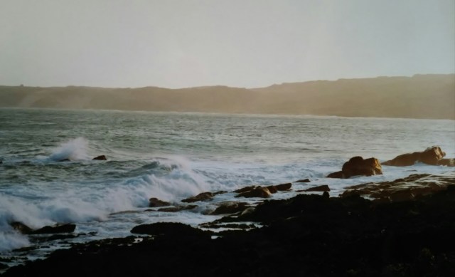
[Huh? What the heck?!] I started heading north along the eastern coastline from Eluanbi, but the bridge that should have been spanning the river right in front of me was nowhere to be seen. I wrote “should have been” because the map clearly shows a bridge there.
[Is it planned to be built? Well, that’s a bummer.] There was no sign of construction, not even a planned construction sign. I bought this map in Taipei. I liked its somewhat Chinese-style (?) color scheme and bought it.
[Oh well. Guess I’ll turn back and go via the mountain route.] I decided that, but I didn’t feel like riding any further that day. It ended up being a night camping by the sound of the waves for the first time in a while.
日本統治時代の鵝鑾鼻は捕鯨基地の最前線、そして東南アジアへの物資の補給基地でもありました。戦時中、アリメカ海軍によって鵝鑾鼻の近海で多くの日本の輸送船が撃沈されています。その慰霊のために鵝鑾鼻を訪れる日本人もいます。
台湾一周も半分終了、この先北上して台北へ戻ることになります。
[あれッ? えッ、どうなってるの?!]鵝鑾鼻から東側の海岸線を北上し始めたのはいいのですが、目の前の川に架かっているべき橋がないのです。〈べき〉と記しましたが、それは地図上にハッキリと橋があるからです。
[橋が架かる予定なのか? それにしてもい参ったな]工事の気配おろか予定看板すら立っていません。地図は台北で購入したものです。どことなく中国風(?)の色使いが気に入って購入したものです。
[しょうがない。引き返して山側から行くか]そうと決めたものの、この日はこれ以上走る気にはなりませんでした。久しぶりに波の音を聞きながらの野宿となりました。
