I head back along the East-West Cross-Island Highway and descend through Taroko Gorge. From Wenshan Hot Springs, I continue along the mountain road, crossing a pass over 3,000 meters high. There’s also a route where, at the fork, you head down toward Yilan instead of Taichung and return to Taipei. However, that feels like it would take me off the “loop” of my trip around Taiwan. Or maybe, to be honest, I just wanted to avoid the grueling mountain roads. Besides, there was one more place I wanted to visit before returning to Taipei.
Passing through the flashy gate on the Cross-Island Highway that I went through yesterday, I turned left and rejoined the Suhua Highway. [I’ll be back in Taipei the day after tomorrow.]
From Chongde, the Suhua Highway begins to follow the coastline. The road gradually climbs along the coast.
[Is this finally the cliff? I wonder what it’s like.] The roughly 20-kilometer stretch of coastline from Chongde to Horen is called the “Qingshui Cliffs.” Qingshui is the name of the area, and there’s even a mountain nearby called Qingshui Mountain. Actually, the couple who told me about Wenshan Hot Springs had said, “The Qingshui Cliffs have great views and are pretty thrilling.” Those Qingshui Cliffs facing the Pacific Ocean were exactly where I wanted to go. The road climbed up the cliff and eventually leveled out, and before long, the sea surface came into view far below.
東西横貫公路を戻って太魯閣峡谷を下ります。文山温泉からそのまま山道を進んで三千m超の峠を越え、分岐を台中ではなく宜蘭(ギラン)へ下って台北へと戻るルートもあります。ただ、それだと台湾一周の「一周」から外れる気がします。いや、本当はキツイ山道を避けたかったのかも知れません。それに台北に戻る前にもう一ヶ所行きたいところがあったのです。
昨日くぐった横貫公路の派手なゲートを再びくぐり、左に曲がると再び蘇花公路に出ます。[あさってには台北に戻れるな]
崇徳(チェンドー)から蘇花公路は海岸線を走るようになります。道は徐々に海岸線を上って行きます。
[いよいよ断崖か、どんなもんだろう]崇徳から和仁(ホーレン)までの海岸線の約20キロ間を「清水断崖(チンシュェイドアンヤー)」といいます。清水はこのあたりの地名で、近くに清水山という山もあります。実は私に文山温泉の存在を教えてくれたご夫婦から「清水断崖は景色がよくてスリルもあるよ」と聞いていました。その太平洋に面した清水断崖が行きたいところでした。
道は崖を上りきりやがて平坦に、いつしか海面が遥か下に見るようになりました。
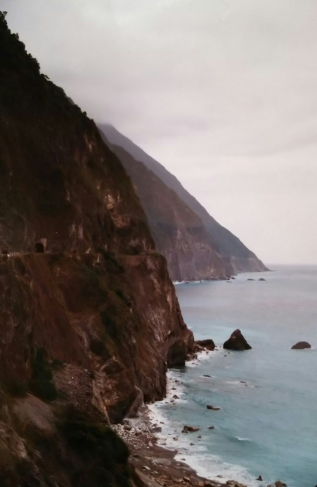
This photo shows the Qingshui Cliffs as seen from the Chongde side. You can clearly see the terrain that has risen from the sea. The cliffs reach a height of 900 meters at their highest point, and the peak visible to the upper left is Mount Qingshui (2,408 meters). The small black dot visible in the center of the cliffs is a hand-dug tunnel; beyond it, the road continues along the cliff face as a thin line—can you make it out in the photo? If the weather had been better, the view of the Pacific Ocean would have been even more spectacular. It’s a shame.
The Suhua Highway winds its way along the sheer cliffs, alternating between paved and unpaved sections as it stretches forward. There is an information board about the Qingshui Cliffs in a small space facing the sea. Alongside that board, the names of Japanese workers who lost their lives during road construction were displayed.
This road was originally built during China’s Qing Dynasty. During the Japanese colonial period, it took 14 years to expand and improve it. It was over 100 kilometers long and was known as the “Coastal Highway.”
The construction work appears to have been extremely grueling. To break up the hard bedrock, workers were suspended from ropes and set off explosives on the cliffs. It is believed that the work was done entirely by hand—using pickaxes and shovels for general labor, and chisels and hammers for tunneling. One can imagine how they lived side by side with constant danger, facing cliff collapses, falling rocks, and the risk of slipping and falling.
I recall there was a memorial monument with the names of those who lost their lives, though they may have also been listed on the information board. I can’t quite recall it clearly. The names were listed by year, and I remember there were quite a few of them.
As I’ll mention later, a new road has since been built, and the route along the Qingshui Cliffs has been abandoned; instead, there are observation decks at various points along the way. I hope that a memorial monument or information board listing the names of those who lost their lives, along with an explanation of the Qingshui Cliffs, has been preserved—but I wonder if that’s the case.
この写真は崇徳側から見た清水断崖です。海から隆起した地形がよくわかります。断崖は高い所で900m、左手上方が清水山(2,408m)です。断崖中央に黒くポツンと見えているのは素掘りのトンネルで、この先薄い線となって断崖を行く道がずっと続いているのですが、写真でわかりますか? 天気がよければ太平洋を望む景色はもっと素晴らしいものになったはずです。残念です。
切り立った断崖を進む蘇花公路は舗装路と地道を繰り返しながら先へと伸びています。海に面したちょっとしたスペースに清水断崖の説明案内板があります。その案内板と一緒に道路工事中に殉職した日本人作業員の名前が掲示されていました。
もともとこの道は中国の清の時代に通されたものです。それを日本統治期に14年かけて拡張、整備を行ったのです。その長さは100キロを超え「臨海公路」と呼ばれていました。
工事はかなり過酷な作業だったようです。固い岩盤を崩すために作業員たちはザイルに宙吊りになり、崖に発破を仕掛けていったのです。おそらく作業はツルハシとスコップ、トンネル掘りはタガネにカナヅチと全て人力で作業を行ったと思われます。崖の崩落や落石、また滑落と多くの事故や危険と隣り合わせにいたのが想像できます。
慰霊碑があって、その碑に殉職者の方々の名前があったと記憶しているのですが、案内板に併記されていたのかも知れません。ハッキリと思い出せないままでいます。名前は年別に掲示されており、かなりの人数だったと記憶しています。
後述しますが、今では新道ができてこの清水断崖を行く道は廃道となり、かわりに所々に見晴台があります。清水断崖の説明文とともに殉職者名が記された慰霊碑か案内板も残されているといいのですが、どうでしょうか。
