Through the “Pedestrian Tunnel” to the Kyushu side. I drop the ¥20 bicycle toll (free for pedestrians) into a mailbox-like payment box and take the elevator down 50 meters underground. It’s 780 meters long—like a really long subway connecting passage. No riding bikes here; you have to walk while pushing. Painted lines marking “Yamaguchi Prefecture” and “Fukuoka Prefecture” divide the center—my first step into Kyushu.
In Fukuoka, I look for a cheap lodging or capsule hotel early. This is because K-kun, a biker I met in Hokkaido, had invited me: “If you come to Hakata, give me a call. Let’s grab a meal together.”
After a quick bath at the capsule hotel to freshen up, I head into town by bike. There’s something I want to do before meeting K-kun. Hakata is famous for mentaiko (spicy cod roe), and I planned to send some as a thank-you gift to the people who helped me along the way. It’s that “one night’s lodging, one meal’s food” gratitude thing. There are mentaiko shops all over town that I’d heard about. So, I picked a shop at random and asked them to ship some.
I was supposed to meet K-kun at the subway entrance at 7 PM, but on my way there, I bumped into him on his moped. At my request, he took me straight to the food stalls in Nagahama.
Every stall was packed with locals and tourists. While Nagahama is often associated with ramen, the street lined with food stalls faces Hakata Port and the fish market, offering an abundance of seafood dishes, including sashimi. Nagahama’s food stalls function as izakayas. K-kun mentioned he was gathering information to drive the Alaska Highway, and our conversation flowed freely over drinks.
「人道トンネル」で九州側へ。郵便受けのような料金箱に自転車の通行料20円(徒歩は無料)を投入して、エレベーターで地下50mまで降ります。長さ780m、地下鉄の長~い連絡道みたいなもんです。自転車に乗るのはダメ、押して歩きます。真ん中へんの白線を境に「山口県」と「福岡県」のペイント、九州への一歩です。
福岡では早めに安宿、カプセルホテルを探します。というのも北海道で出会ったバイクライダーのK君から「博多に来たら連絡下さい。一緒に飯でも食べましょう」と誘われていたのです。
カプセルホテルでひとっ風呂、サッパリしてから自転車で街へ。K君と会う前にやりたいことがあります。博多といえば明太子、その明太子を道中お世話になった方々にお礼として送るつもりでいました。「一宿一飯」の恩義というヤツです。街のアチコチに聞いたことのあるような明太子のお店があります。ということで、適当にお店を選んで配送を依頼。
K君とは7時に地下鉄の入り口で待ち合わせ、ところが待ち合わせ場所へ向かう途中で原付バイクの彼とバッタリ。そのまま私の希望で長浜の屋台へと案内してもらいました。どの屋台も地元の人や観光客で満員です。長浜といえばラーメンと思いがちですが、屋台の並ぶ通りの向こうは博多港に面した魚市場、刺身を始め魚料理も充実しています。長浜の屋台は居酒屋です。K君はアラスカハイウェイを走るべく情報収集中とのこと、一杯飲みながらの話が弾みました。
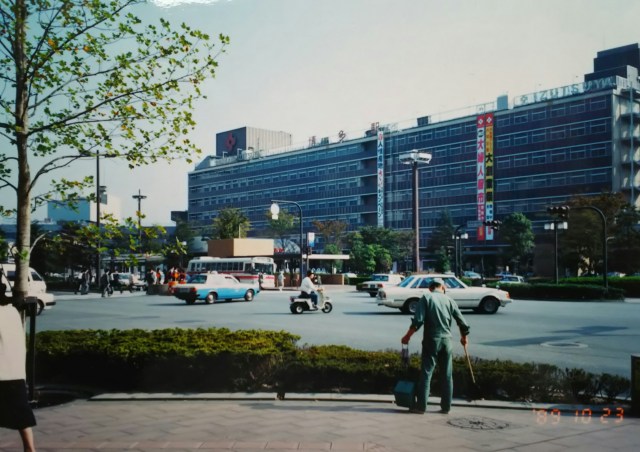
This photo shows Hakata Station. Although it’s in Fukuoka Prefecture and Fukuoka City, there is no station named Fukuoka Station. What exists is Hakata Station, which seems to have some sort of historical connection dating back to the Edo period.
The name Hakata already appears in records from the Nara period. Hakata flourished as a merchant town due to trade with the continent and special demand from the Korean campaigns. The name Fukuoka had not yet appeared.
In the early Edo period, Kuroda Kanbei (familiar from NHK’s historical drama “Kanbei the Strategist”) built a castle with his eldest son Nagamasa in Fukusaki, west of the Naka River (Chikuzen Province, Fukuoka Domain). At that time, he renamed Fukusaki to Fukuoka, inspired by his birthplace of Fukuoka in Bizen Province (present-day Fukuoka, Osafune-cho, Setouchi City, Okayama Prefecture), and named the castle Fukuoka Castle.
This decision, not naming it Hakata Castle, went against the common people’s expectation that it would naturally become Hakata Castle. This became the root cause of various disputes later on. As a result, the area west of the Naka River became the samurai town of Fukuoka, while the east became the merchant town of Hakata, clearly dividing the two.
Even during the abolition of the han and establishment of prefectures in the early Meiji period, it became Fukuoka Prefecture, not Hakata Prefecture. When the subsequent municipality system was implemented, it was designated as Fukuoka City by prefectural ordinance. The following year, a motion to change the city’s name was again brought before the city council. With both the population and the number of council members favoring the Hakata side, it was widely expected that the city would become Hakata City. However, the vote ended in a tie, and ultimately, the chairperson’s single vote decided it would be Fukuoka. The chairperson was of samurai descent.
Given this history, and in an effort to strike a balance, the newly opened Kyushu Railway station was named Hakata.
In 1972, when Fukuoka City was elevated to a government-designated city, Hakata Ward was created as part of the new administrative division. After many long years, the place name Hakata was finally revived.
So far, I’ve seen bronze statues of warlords connected to their respective regions, like Date Masamune and Mōri Terumoto (and later, Katō Kiyomasa, Saigō Takamori, Sakamoto Ryōma, etc.). Yet, Fukuoka has no statues of Kuroda Kanbei or the Kuroda Nagamasa father-son duo. The samurai statue once in front of Hakata Station, holding a spear and a sake cup, was modeled after the folk song “Kuroda Bushi.”
Hakata dolls, Hakata obi sashes, Hakata Yamakasa floats, Hakata dialect, Hakata ramen… and Hakata locals.
It seems Lord Kuroda is disliked by the Hakata locals. Despite the Kanbei boom from the historical drama series, there appears to be something between Fukuoka and Hakata preventing a statue of the lord from being erected.
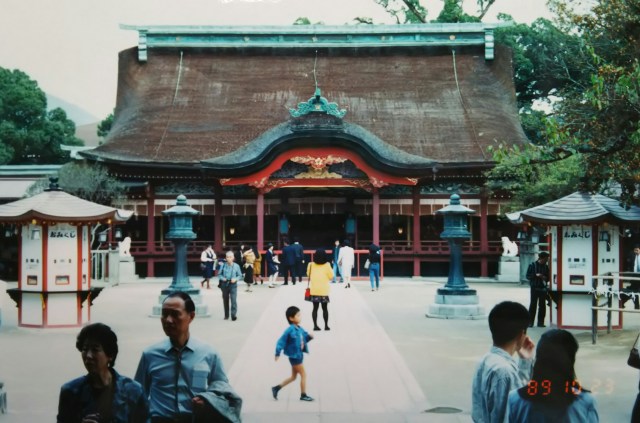
The next photo is of Dazaifu Tenmangu Shrine. It enshrines Sugawara no Michizane, who was exiled from the capital to this land.
This year(2018), the new era name “Reiwa” was decided, and its source is the “Preface to the Thirty-Two Poems on Plum Blossoms” from the Manyoshu anthology, putting Dazaifu Tenmangu in the spotlight. This is because it is said that the author of that preface was Otomo no Tabito, who was both the compiler of the Manyoshu and the Governor of Dazaifu.
The 32 poems were composed during the “Plum Blossom Banquet” held at Otomo no Tabito’s residence near the shrine. The grounds of Dazaifu Tenmangu feature some 6,000 plum trees, making it renowned as a plum blossom viewing spot. The plum blossom is also the emblem of Tenmangu.
写真は博多駅です。福岡県とか福岡市とはいうものの福岡駅という駅名はありません。あるのは博多駅、そこには何やら江戸時代からのいわく因縁があるようです。
奈良時代にすでに博多の地名が出てきます。博多は大陸との交易や朝鮮出兵の特需などで商人の町として栄えていきます。まだ福岡という地名は登場しません。
江戸時代の初期、黒田官兵衛(NHKの大河ドラマ「軍師官兵衛」でお馴染み)は、長男の長政とともに那珂川の西にある福崎の地に築城します(筑前国福岡藩)。その際、官兵衛の生まれ故郷の備前国福岡(現在の岡山県の瀬戸内市長船町福岡)にちなんで、福崎を福岡と改名した上で城の名を福岡城とします。ここで博多城としなかった、つまり当然博多城になると思っていた庶民の意に反したのです。それが後々何かともめるもモトとなったのです。結果、那珂川の西が武士の町福岡、東が商人の町博多とハッキリと分けられてしまいます。
明治の初期、廃藩置県の際も博多県ではなく福岡県になります。続く市町村制度の施行でも県令で福岡市とします。翌年、市議会で再び市の名称をどうするか動議にかけられます。人口、議員ともに博多側の方が多く、博多市になるものと思われていました。ところが採決は同票、最終的に議長の一票で福岡で決定します。議長は武家の出身でした。
そんな経緯があり、バランスを取る意味で開通したばかりの九州鉄道の駅名を博多としたのです。
1972年、福岡市が政令指定都市として格上げされる際の区分けで博多区が生まれます。地名としての博多が長い年月を経てやっと復活したのです。
これまで伊達政宗や毛利輝元などその土地ゆかりの武将の銅像を見てきました(この先も加藤清正、西郷隆盛、坂本龍馬など)。ところが福岡には黒田官兵衛、長政父子の銅像がありません。博多駅前にあった武士の銅像は槍と盃を手にした民謡「黒田節」のモデルでした。
博多人形、博多帯、博多山笠、博多弁、博多ラーメン…… そして博多っ子。
どうやら黒田の殿様は博多っ子に嫌われているようです。大河ドラマの官兵衛ブームがあったにもかかわらず、殿様の銅像を設置できない何かが福岡と博多の間にあるようです。
続いての写真は太宰府天満宮です。都からこの地へ流された菅原道真を祀っています。
今年、新元号が「令和」に決まり、その出典元が万葉集の「梅花の歌32首の序文」ということで、太宰府天満宮が脚光を浴びています。というのもその序文を書いたのが万葉集の編者でもあると同時に太宰府長官でもあった大伴旅人ではないかといわれているからです。
天満宮近くの大伴旅人の邸宅で開かれた「梅花の宴」の際に32首の和歌が詠まれたのです。太宰府天満宮の境内には6,000本もの梅の木があり、梅の名所として知られています。梅花が天満宮の紋様となっています。

From Dazaifu, I took National Route 3 to Saga Prefecture. In Tosu, I visited Mr. N, a teacher at a prefectural high school. Seven years ago, while driving from Glacier National Park to Yellowstone National Park in the U.S., I met Mr. N and four others, and they treated us to breakfast. They were all members of the same cycling club, though they were on a sightseeing trip in a car driven by an American driver/guide. I had met Mr. N once before in Tokyo two years ago, so this would be our second reunion.
After reuniting, we head to the Yoshinogari Kofun burial mounds pictured here. That year, the Yoshinogari Kofun gained nationwide fame. Excavated artifacts had already revealed that people lived in this hilly area south of the Sefuri Mountains, straddling Fukuoka and Saga Prefectures, during the Yayoi period.
Saga Prefecture, which had planned to attract a large-scale factory to this site, began full-scale preliminary surveys of the surrounding area. In 1989, the remains of a large settlement, the Yoshinogari Kofun, were discovered. As a result, the factory site was scaled back, and full-scale excavation of the ancient burial mounds began.
Pit dwellings and raised-floor storehouses, like the ones in the photo, had already been reconstructed. However, excavation work was still ongoing in the surrounding area, and it continues to this day.
太宰府から国道3号線で佐賀県へ。鳥栖で県立高校の先生Nさんを訪ねます。この7年前、アメリカのグレイシャー国立公園からイエローストーン国立公園へ向けて走行中にNさんたち5人と出会い、朝食をご馳走になっていました。皆さん同じサイクリングクラブのメンバー、もっともアメリカ人ドライバー兼ガイドの運転する車での観光旅行中でした。Nさんとは2年前に東京で一度お会いしてますから、二度目の再会になります。
再会後、写真の吉野ヶ里古墳へ向かいます。この年、吉野ヶ里古墳は全国的に有名になります。もともと出土品などから福岡と佐賀にまたがる脊振山地の南側のこの丘陵地帯で弥生時代に人々が暮らしていたとわかっていました。
この地に大規模な工場誘致を計画していた佐賀県は、周辺の本格的な事前調査を開始します。1989年に大規模な集落の跡、吉野ヶ里古墳が発見されます。結果、工場用地は縮小され、本格的な古墳の発掘調査が始まったのです。
すでに写真のような竪穴式住居や高床式倉庫が復元されていました。しかし周辺はまだ発掘作業中、その作業が今も続いているそうです。
From Saga to Takeo, famous for its velodrome and hot springs. So, after a quick soak, we’re heading to Arita.
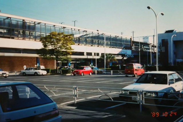
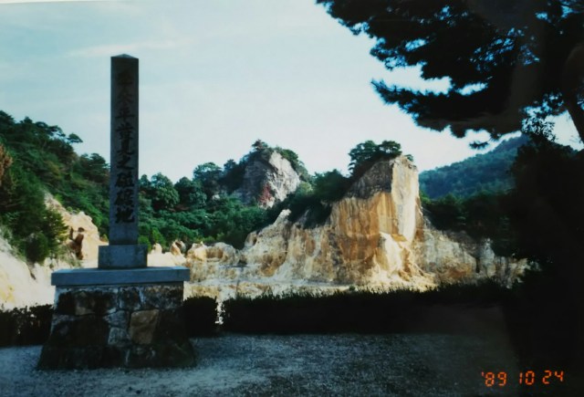
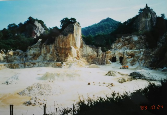
This photo is of Saga Station. Arita is known for its white porcelain, Arita ware. The next photo is of the “Izumiyama Porcelain Stone Quarry,” a porcelain stone quarry on the outskirts of Arita. This quarry was discovered by Lee Sanpyeong, a potter brought from the Korean Peninsula by Naoshige Nabeshima, the first lord of the Nabeshima domain. Prior to this, Japanese pottery was primarily earthenware; the technology to fire thinner, harder porcelain did not exist. Lee Sam-pyeong searched the domain of the Nabeshima clan for porcelain stone suitable for firing porcelain and arrived at this “Izuyama Porcelain Stone Quarry.” The stone pillar bears the inscription “Lee Sam-pyeong’s Discovered Porcelain Mine Site.” The yellow porcelain stone contains high iron content, enabling the firing of superior porcelain. This quarry is no longer in use.
Today, Arita ware is fired using porcelain stone from Amakusa, Kumamoto Prefecture. Lee Sam-pyeong is revered as the founding father of Arita ware, and the Toso Festival is held annually on May 4th to express gratitude. After this, we visit the Arita Porcelain Museum in Arita town, housed in a Meiji-period pottery warehouse.
We drive from Arita to Nagasaki along National Route 202. Immediately after leaving Arita, we enter Nagasaki Prefecture. Along the way, we detour off Route 202 to visit Sasebo Port. The port has been in the news for the arrival of the nuclear-powered aircraft carrier USS Enterprise and radiation leaks from nuclear submarines, which piqued our interest.
Sasebo is a lively port town, but only military vessels and fishing boats are moored or anchored within the harbor. Before the war, Sasebo Port was a Japanese military port. After the Korean War, it was designated a “specified port” and functioned as a U.S. military port. Consequently, merchant ships and passenger vessels, except fishing boats, require special permission to dock. It’s that thing about the Status of Forces Agreement – even in Japan, you can’t do things the Japanese way. Only in the Heisei era did a dedicated wharf for large passenger ships finally get built.
Returning to Route 202. Crossing the Saikai Bridge brings you to the Nishisonogi Peninsula. For the first time in a while, I’m driving on a road with few cars. All I see is sea and sky, following the coastal ups and downs through Saikai Town, Oseto Town, and then Sotome Town. Currently, Saikai Town and Oseto Town have merged with surrounding areas to form Saikai City, while Sotome Town has been incorporated into Nagasaki City.
佐賀から競輪場と温泉で有名な武雄へ。ということで、ひとっ風呂浴びて有田へ向かいます。
写真は佐賀駅です。有田といえば白磁で知られる有田焼、次の写真は有田の町外れにある陶石採石場「泉山磁石場」です。この採石場は鍋島藩初代藩主、鍋島直茂によって朝鮮半島から連れてこられた陶工、李参平によって発見されました。それまでの日本の焼き物はいわゆる陶器で、より薄く固い磁器を焼く技術はありませんでした。李参平は磁器を焼くのに適した陶石を鍋島藩の領地内を探し歩き、この「泉山磁石場」にたどり着いたのです。石柱には「李参平発見之磁鑛地」とあります。黄色い陶石は多くの鉄分を含んでいて、より良い磁器が焼けるのです。現在、この採石場は使われていません。今は熊本県天草の陶石で有田焼は焼かれています。李参平は有田焼の陶祖とされ、毎年5月4日に感謝を込めて陶祖祭が催されています。この後、有田の町で明治期の焼き物倉庫を利用した「有田陶磁美術館」に寄ります。
有田から国道202号線を長崎まで走ります。有田を出ればすぐに長崎県、途中で202号線を外れて佐世保港に寄ります。原子力空母エンタープライズの入港、原潜の放射能もれと何かと話題になっており、興味があったのです。
佐世保は活気のある港町ですが、港内に停泊、係留しているのは軍艦と漁船だけです。戦前、佐世保港は日本の軍港でしたが、朝鮮戦争以降、特定港に指定されアメリカの軍港として機能します。そのため漁船を除く商船や客船が停泊するには特別な許可が必要となるのです。安保の地位協定、日本であっても日本方式にできないというヤツです。平成になってやっと大型客船専用の岸壁ができています。
202号線へ戻ります。西海橋を渡ると西彼杵(にしそのぎ)半島です。久しぶりに車の少ない道を走ります。眼に映るのは海と空、海沿いのアップダウンを繰り返して西海町、大瀬戸町、そして外海(そとめ)町へ。現在、西海町と大瀬戸町は周辺と合併して西海市に、外海町は長崎市に組み込まれています。
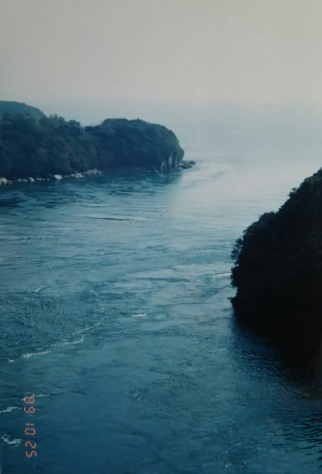
The photo shows the view from Saikai Bridge spanning Sasebo City and Saikai Town. This area is called Hario Seto (Hario is the name of an island), connecting Omura Bay with the open ocean beyond at its narrowest point of just 170 meters. Harino Seto is counted among Japan’s three major tidal currents.
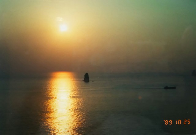
Next, the beautiful sunset sinking into Sumo Nada off the coast of Kurosaki, Gaikai Town.
In 2005, the roadside station “Yūhi-ga-oka Sotome” opened on a hill with a great view in Kurosaki. Truly, the sunset sinking into Sumo Nada is the best in Japan (?).
Next time, we head from Nagasaki to Unzen and Shimabara.
写真は佐世保市と西海町にかかる西海橋からの眺めです。ここは針尾瀬戸(針尾は島の名)と呼ばれ、狭いところでわずか170m、大村湾とこの先遠く外洋とをつないでいます。針尾瀬戸は日本三大急潮の一つに数えられています。
続いて外海町黒崎の海辺、角力灘(すもうなだ)に沈む美しい夕日。
2005年、その黒崎の見晴らしのよい丘に道の駅「夕陽ヶ丘そとめ」がオープンしました。やっぱり、角力灘に沈む夕日は日本一(?)です。
次回、長崎から雲仙、島原へと向かいます。
