About 30 kilometers from Kurosaki in Sotoumi Town, I arrived in Nagasaki early. After sightseeing around the city until evening, I plan to thoroughly enjoy the famous night view.
First, I’ll head to the Atomic Bomb Museum (formerly the Atomic Bomb Information Center) at the Cultural Center. Next, I’ll go from Peace Park to Urakami Cathedral.
外海町の黒崎から30キロほど、早めに長崎に到着。夕方まで市内見物した後で名物の夜景をじっくり堪能するつもりです。
まずは文化会館の原爆資料センター(現在の原爆資料館)へ。次に平和公園から浦上天主堂へと向かいます。
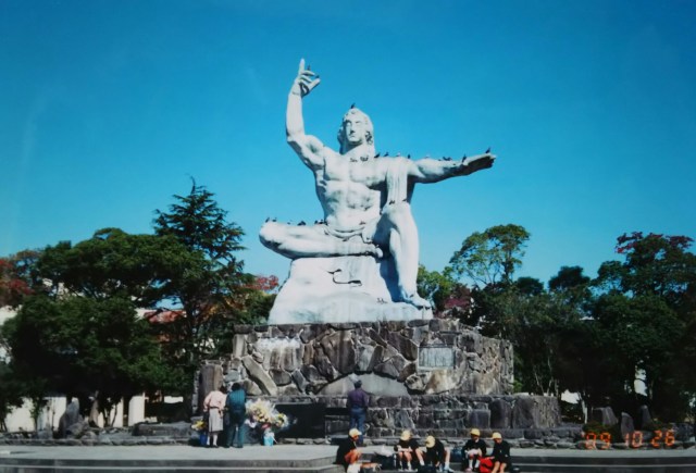
The photograph shows the “Peace Memorial Statue,” approximately 10 meters tall, located on a small hill in the northern corner of Peace Park. Elementary school students are sketching nearby, perhaps on a field trip.
This statue was created in 1955 by the Nagasaki-born sculptor Seibo Kitamura. The 30 million yen production cost was funded by donations from both within and outside Japan. Seibo’s studio and sculpture museum are located within the Inokashira Park in Musashino City, Tokyo, where a replica of this giant statue is displayed. I remember seeing it myself on a primary school field trip.
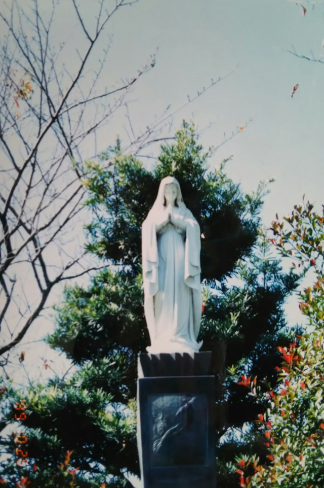
Next is the statue of Mary inside Urakami Cathedral (church) in the eastern part of Peace Park.
Urakami Cathedral was a sanctuary for the so-called hidden Christians. Like the Edo shogunate, the Meiji government banned Christianity, forcing Nagasaki’s Catholics to relocate across the country. After the ban was lifted, the first thing the returning believers did was build a small chapel. This became the later Urakami Cathedral.
Urakami Cathedral was located about 500 meters northeast of the southern edge of Peace Park at the hypocenter and collapsed due to the atomic bomb. The current church was rebuilt after the war.
Statues of Mary can be broadly categorized into three forms: holding the infant Jesus to her chest, standing with arms outstretched, and, as in the photo, praying with hands pressed together.
This statue of Mary was gifted by the Italian Catholic Medical Association, deeply moved by the rescue efforts for atomic bomb survivors and the peace advocacy of Dr. Takashi Nagai of Nagasaki Medical University. Dr. Nagai, himself a Catholic, suffered from leukemia and was also a survivor of the atomic bombing.
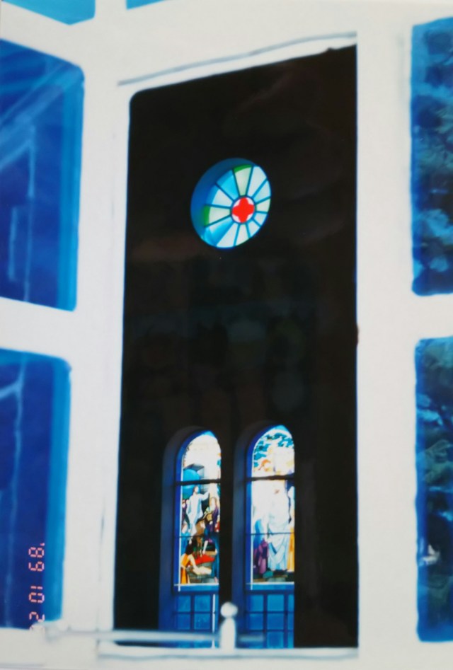
Finally, here is the stained glass window along the wall of the chapel.
写真は平和公園の北の一角、小高い丘にある高さ約10mの「平和祈念像」です。校外学習でしょうか、周辺で小学生が写生をしています。
この像は1955年に長崎出身の彫刻家北村西望によって制作されました。制作費の3,000万円は内外からの寄付によるものです。東京武蔵野市の井の頭自然文化園内に西望のアトリエと彫刻館があり、この巨人像のレプリカが展示されています。私も小学校の遠足で見た記憶があります。
続いて平和公園の東、浦上天主堂(教会)内のマリア像です。
浦上天主堂はいわゆる隠れキリシタンの拠り所でした。明治政府も江戸幕府同様にキリスト教を禁制とし、長崎のカトリック教徒たちを全国各地へと追いやる形で転居させます。禁制解除後、浦上に戻った教徒たちが真っ先に手掛けたのが小聖堂を建てることでした。それが後の浦上天主堂です。
浦上天主堂は爆心地の平和公園の南端から北東へ500mほどに位置しており、原爆投下により倒壊しました。現在の教会は戦後に再建されたものです。
マリア像の形は大きく分けて三つ。胸に幼児のキリストを抱く姿、両手を広げて立つ姿、そして写真の合掌して祈る姿です。
このマリア像は長崎医科大の永井隆博士の被爆者の救護、平和を訴える活動に感銘を受けたイタリアのカトリック医師会から贈られたものです。カトリック教徒でもあった永井博士は白血病を病んでいた上に自らも被爆しています。
最後は礼拝堂の壁際のステンドグラスです。
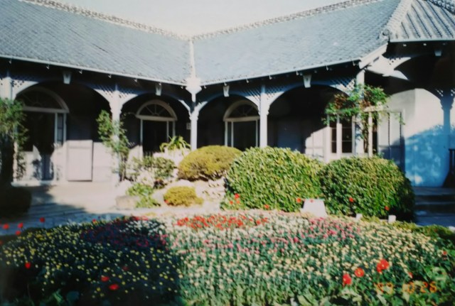
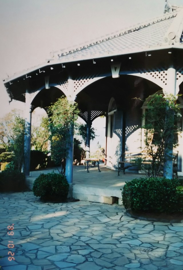
From the city center, head south along the coast. The Glover Garden occupies the area of a small hill. Long ago, this area was a foreign settlement. Climbing the slope within the garden brings you to the Glover House, the residence of the Scottish merchant Glover, pictured here. Along the way, several buildings with Western-style exteriors and Japanese roof tiles—a somewhat unusual combination—can be seen.
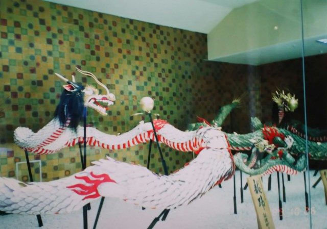
The photo shows the white dragon used in the snake dance of the “Nagasaki Kunchi” festival. It’s displayed at the “Nagasaki Traditional Performing Arts Museum” adjacent to the Glover House.
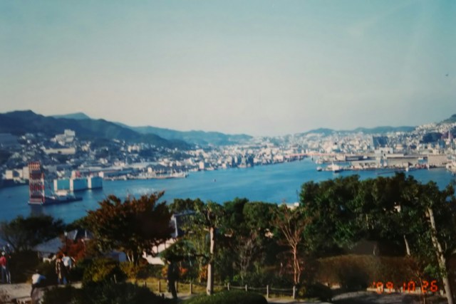
Finally, this is Nagasaki Port, photographed on the way down. The mountain on the left in the photo is Mount Inasa (333m), now a park and a place of relaxation for citizens. A ropeway runs to the summit, and the observatory is an excellent spot to enjoy Nagasaki’s night view. After this, I cycled up to the observatory as dusk fell and took my time admiring the night view.
Leaving Nagasaki, I headed from Isahaya to the Shimabara Peninsula. Nagasaki had more ups and downs than I expected, leaving me a bit tired. I took a quick bath (¥100) at the public bathhouse in Kohama Onsen, facing Tachibana Bay on the peninsula’s west side, then camped on the steaming sandy beach. I prepared for the climb to Unzen the next day.
街の中心から海沿いを南へ。小高い丘一帯がグラバー園です。昔、このあたりは外国人の居留地でした。園内の坂道を上って行くと写真のスコットランドの貿易商人のグラバー邸があります。途中、洋風の外観に日本瓦というちょっと変わった感じの建物が何軒か見られました。
写真は「長崎くんち」の蛇踊りに使われる白龍です。グラバー邸に隣接する「長崎伝統芸能館」に展示されています。
最後は下る途中で撮った長崎の港です。写真の左の山は稲佐山(標高333m)、公園になっており、市民の憩いの場です。頂上までロープウェイがあり、展望台は長崎の夜景を楽しむ絶好のポイントになっています。このあと日が暮れる中を展望台まで自転車で上り、夜景をじっくり眺めます。
長崎を後に諫早から島原半島へ。長崎は思いのほかアップダウンが多く、少々疲れぎみです。半島の西、橘湾に面した小浜温泉の共同浴場でひとっ風呂(入浴料100円)浴び、湯煙たつ砂浜でテント泊。翌日の雲仙への上りに備えました。
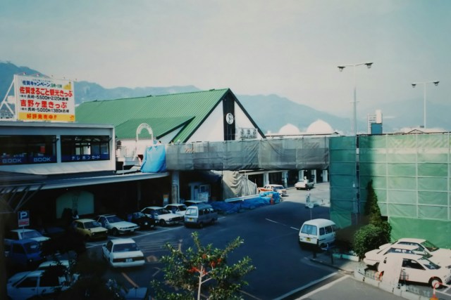
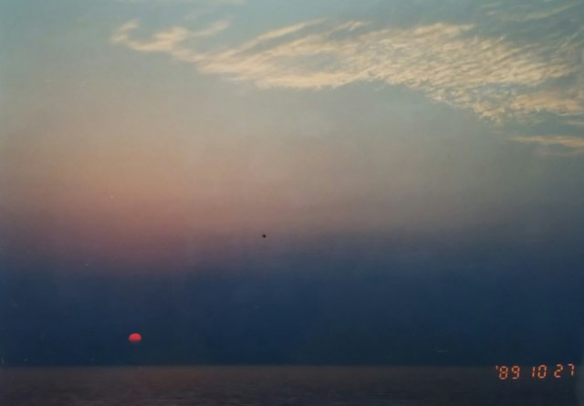
One photo of Nagasaki Station before heading out in the morning. Next is the sunset sinking into the perfectly calm Tachibana Bay. The opposite shore is the Nagasaki Peninsula.
朝、出掛けに長崎駅の写真を一枚。次はベタなぎの橘湾に沈み行く夕日です。対岸は長崎半島になります。
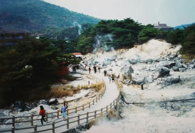
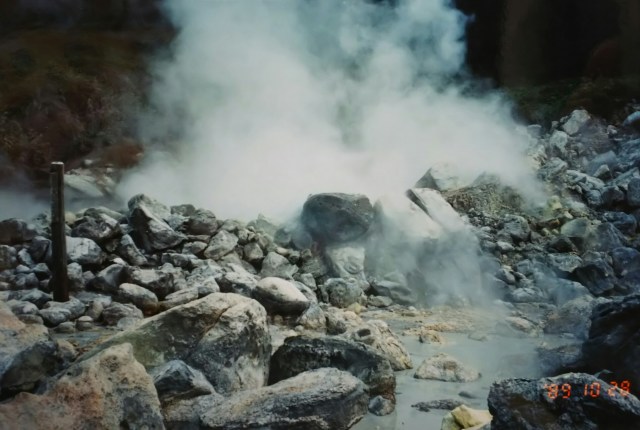
Twelve kilometers up the winding road from Obama, gaining about 700 meters in elevation, lies Unzen at the center of the peninsula. The photo shows Unzen Jigoku (Hell).
Unzen brings to mind the great eruption of Mount Fugen. The very next month after my visit, swarm earthquakes—said to be precursors to the major eruption—began occurring in Tachibana Bay. Then, the following year, November 1990, saw the start of eruptions not seen since the Edo period. This culminated in the major eruption on June 3, 1991, followed by associated debris flows and massive pyroclastic flows reaching Fukae Town east of Mount Fugen and Shimabara City. It was a major disaster, claiming over 40 lives, primarily among the press corps, and damaging more than 2,500 buildings. Recent studies indicate that Unzen had already entered a period of volcanic activity by the late 1960s.
小浜からつづら折りを上ること12キロ、700mほど標高をかせぎ半島の真ん中、雲仙へ。写真は雲仙地獄です。
雲仙といえば普賢岳の大噴火を思い出します。私が訪れた翌月から大噴火の予兆だったといわれる群発地震が橘湾で起こり始めます。そして翌年の1990年11月、江戸時代以来の噴火に始まり、1991年6月3日の大噴火、それに伴う土石流と普賢岳の東の深江町、島原市への大火砕流発生へと続きました。報道陣を中心に40人以上の犠牲者、2,500棟以上の建物被害という大災害でした。最近では1960年代後半に雲仙はすでに火山活動期に入っていたとされています。
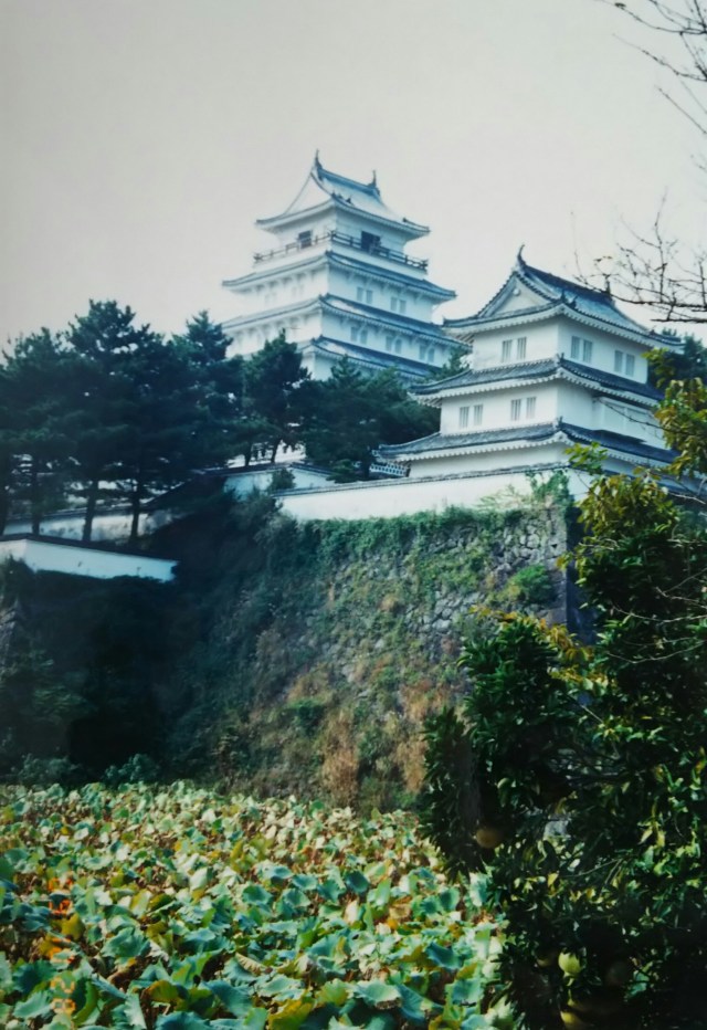
From Unzen, we descend straight to Shimabara, passing the golf course along the way. The photo shows Shimabara Castle and the samurai residences. The castle was reconstructed during the Showa period.
Shimabara is famous for the “Shimabara Rebellion,” Japan’s largest peasant uprising. The original lord of Shimabara Domain was Arima Harunobu, a warlord from the Sengoku period who was also a Christian daimyo. His castle was Hinoe Castle, located in the southern part of the peninsula, but due to various circumstances, he was exiled to Kai Province. His successor, Matsudaira Shigemasa, abandoned Hinoe Castle and built Shimabara Castle anew. The funding for this castle construction and the collection of annual taxes were extremely harsh, and it is said this severity did not lessen even during famines. Eventually, discontent among the peasants erupted. They, along with some rōnin and Christians, launched the uprising known as the Shimabara Rebellion. The rebel army’s leader, Amakusa Shiro, used the abandoned Hinoe Castle and the coastal Hara Castle as bases, while the shogunate forces fought from Shimabara Castle.
The rebel army was completely annihilated. After the Shimabara Rebellion, persecution of Christians intensified further. The Tokugawa shogunate expelled foreigners and moved toward sakoku (national isolation). The Shimabara Rebellion is considered significant in Japanese history, so you likely learned about this in class.
To the north of Shimabara Castle lived samurai with high rice allotments (ishitaka), while the seven neighborhoods to the west housed samurai with lower allotments, including musket units.
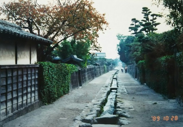
The photo shows the “Samurai Residence Preservation District” in one of these neighborhoods, “Shita-no-cho.” Shimabara was rich in clear streams, and during the Edo period, waterways for daily use flowed through the town. Nowadays, with the development of automobiles, these waterways have been filled in, tunneled under, or moved to the side of the road for accident prevention.
This preservation district is unique in that the waterways remain right in the middle of the roads, just as they were in the Edo period. The straight road stretches for over 400 meters. Each residence was quite spacious, and according to domain orders, they planted fruit trees like persimmons, citrus, and plums. Unlike samurai residences in other regions, the long, continuous stone walls here feel particularly characteristic. Within the preservation district, you can tour designated residences free of charge.
Next time, I’ll take the ferry to Kumamoto and climb Mount Aso.
雲仙からゴルフ場を横目に一気に島原まで下ります。写真は島原城と武家屋敷です。お城は昭和期に復元されました。
島原といえば「島原の乱」、日本最大の一揆です。島原藩主はもともと戦国大名の一人でキリシタン大名でもある有馬晴信でした。居城は半島の南にある日野江城でしたが、諸々あって甲斐国へ流されます。代わりの藩主松平重政は日野江城を廃城とし、島原城を新たに築城します。築城にあたっての資金調達、年貢の取り立てが非常に厳しく、飢饉でもその厳しさは変わらなかったといわれています。やがて不満が爆発した農民は一部浪人をまじえたキリシタンとともに一揆「島原の乱」を起こします。一揆軍の大将、天草四郎は日野江城の離城、海辺の原城を拠点として、かたや幕府軍は島原城を拠点として戦ったのです。一揆軍は全滅、「島原の乱」以後キリシタン弾圧はさらに強まり、徳川幕府は外国人を追い出し、鎖国へと進んで行きます。日本史でも「島原の乱」は重要とされていますので、この辺は授業で習ったと思います。
島原城の北側には扶持高(石高)の高い武士、西側の7つの町内には鉄砲隊など扶持高の低い武士が暮らしていました。写真はその中の一つ「下の丁」の「武家屋敷町並み保存地区」です。島原は清流が豊富で江戸時代には町中に生活用水路が流れていました。車が発達した今では事故防止のため埋め立てやトンネル化、また道の片側に寄せられたりしています。江戸時代そのままに道の真ん中に用水路が残されているのがこの保全地区です。まっすぐ延びた道は400m以上もあります。それぞれの屋敷はかなり広く、藩命により柿、柑橘、梅など果樹木を植えたそうです。他の地方の武家屋敷と違って長く続く石垣が特徴的に感じられます。保存地区では指定された屋敷内を無料で見学できます。
次回、フェーリーで熊本に渡り、阿蘇山に上ります。
