From Tabira Port in Kunimi Town, north of Shimabara Peninsula, I took a ferry across the Ariake Sea to Choshu Town in Kumamoto Prefecture. The trip took about 45 minutes (fare was ¥310, including my bicycle), and I shared the ferry with students on a school trip.
Kumamoto is known for its thriving agriculture, producing the highest volume of many crops in Japan, including tomatoes, watermelons, and summer oranges. As if to prove this, the plains open up, with fields and plastic greenhouses catching the eye. I reached Kawachi Town, known for its mandarin oranges, just under 20 kilometers from Kumamoto City, but dusk was falling fast. I asked a young couple who had just finished harvesting their rice if we could pitch our tent in an empty space in their field. Kumamoto is known for its early-harvest rice, but it was already late October, and this seemed to be the last rice harvest of the year.
島原半島の北、国見町の多比良港からフェリーで有明海を渡り、熊本県の長州町へ。所要時間約45分(料金は自転車とも310円)、修学旅行の生徒たちと一緒でした。
熊本は農業が盛ん、トマトやスイカや夏みかんなど多くの農産物の生産量が日本一です。それを証明するかのように平野部が開け、畑やビニールハウスが目につきます。熊本市内まで20キロ弱、みかんで知られる河内町まで来ましたが、だいぶ日が暮れてきました。ちょうど稲刈り作業を終えた若いご夫婦にお願いして畑の空きスペースにテントを張らせてもらうことに。熊本は早期米で知られていますが、すでに10月末、この年最後の稲刈り作業のようでした。
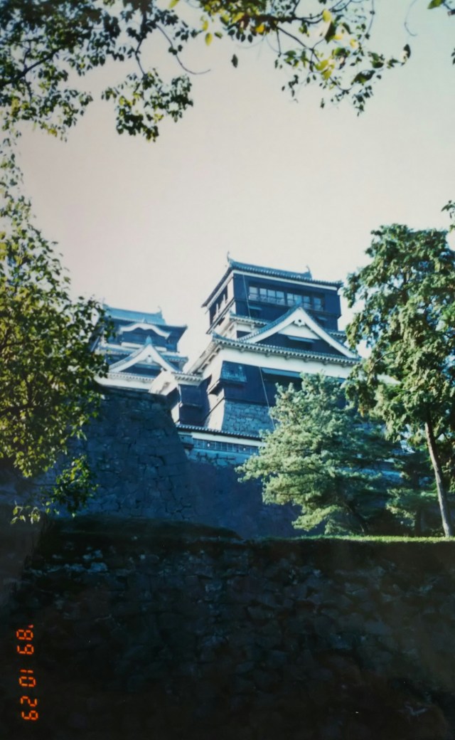
This photo shows Kumamoto Castle. Built in the early 17th century by Kiyomasa Kato, it later came under the control of the Mouri clan. During the Satsuma Rebellion, a fire destroyed the main keep and palace, but it was rebuilt in reinforced concrete after the war. Much of the castle suffered damage in the April 2016 Kumamoto Earthquake and is currently undergoing restoration.
At a bicycle shop in Suizenji, I bought a rearview mirror and also got information about Mount Aso, my next destination. That year, volcanic activity at Mount Aso had intensified, and I’d heard some radio news about damage to crops from ash fall.
The shop owner said, “This month, the eruptions from Nakadake have intensified even more. Ejecta the size of a person’s head are flying up, and mountain access is currently restricted.” It seemed unlikely I’d be able to peer into the crater, but I decided to go as far as I could.
I rode about 30 kilometers along National Route 57, which runs parallel to the Hohi Main Line from the city center, and camped my tent near Akamizu Station at an elevation of 467 meters. As expected, it got quite chilly on the outer rim of Mount Aso. Currently, Akamizu Station is closed for demolition after being damaged in the Kumamoto Earthquake.
From Akamizu, we drove 13 kilometers on the toll road “Aso Mountain Road” to Kusasenri. There, I could see the smoke plume from Nakadake, one of the Aso Five Peaks, accompanied by a roaring sound.
写真は熊本城です。17世紀の初めに加藤清正により築城され、その後は毛利家
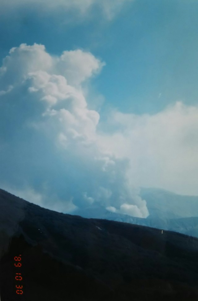
Past Kusasenri, along the ash-covered toll road, I approach Nakadake. This photo was taken at the junction where we came close again. The road ahead was closed.
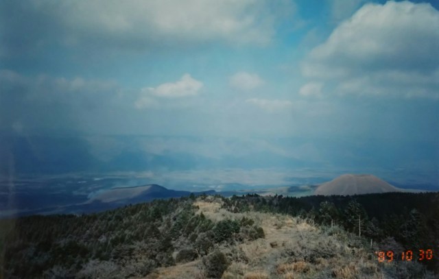
Finally, a photo from inside the Aso Caldera. The Aso caldera was formed by volcanic activity spanning hundreds of thousands of years. It is said the current shape resulted from a major eruption 90,000 years ago. The caldera spans 25 kilometers north-south and 18 kilometers east-west. Approximately 50,000 people live within this alluvial plain. There were rice fields and farmland, of course, as well as a university campus and golf courses.
From the fork, I head south on the Aso Mountain Road, driving outside the outer rim. In 2000, the Aso Mountain Road became toll-free and is now called the “Aso Panorama Line.”
草千里から降灰で白っぽい有料道路をさらに先へ、中岳へ近づきます。そして再接近した分岐点での写真です。この先は通行止めになっていました。
最後は阿蘇カルデラ内の写真です。阿蘇のカルデラは数十万年にも及ぶ火山活動により形成されました。9万年前の大噴火により現在の形になったといわれています。カルデラの大きさは南北25キロ、東西18キロ、この沖積平野の内で約5万人が暮らしています。田畑はもちろん大学のキャンパス、ゴルフ場もありました。
分岐点から阿蘇登山道路を南へ、外輪山の外へと走ります。2000年に阿蘇登山道路は無料化され「阿蘇パノラマライン」と呼ばれています。
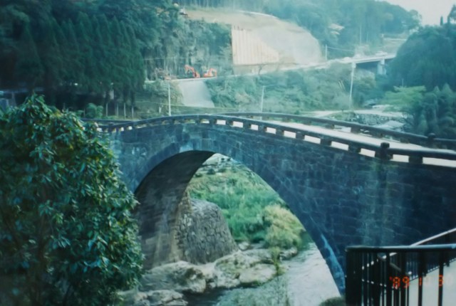
This photo shows the stone arch bridge “Reidai Bridge” over the Midorikawa River, spotted in Tomochimachi on the way to Yatsushiro. Completed in 1846, it spans about 100 meters.
Most of Japan’s stone bridges are concentrated in Kyushu, with roughly half of them found in Kumamoto. Tomochimachi alone has over 30 stone bridges of various sizes. The reason lies in the presence of the Taneyama stonemasons, a group of highly skilled craftsmen based in Taneyama Village (now Toyo-machi, Yatsushiro City) since the Edo period. The old Nijūbashi Bridge at the Imperial Palace, Nihonbashi Bridge, and Asakusabashi Bridge were also built by the Taneyama stonemasons. Tomochi Town merged with the adjacent Chūō Town and is now Tomochi, Misato Town, Shimomashiki District.
Next time, from Kumamoto to Kagoshima. I’ll drive from Sakurajima along Kinko Bay, through the Osumi Peninsula, and onto the Satsuma Peninsula.
写真は八代へ向かう途中、砥用町(ともちまち)で見かけた緑川にかかる石造りのアーチ橋「霊台橋(れいだいきょう)」です。1846年に完成、長さ100mほどです。
九州には日本の石造りの橋のほとんどが、そしてその約半数が熊本に集中しています。砥用町にも大小合わせて30以上の石造りの橋があります。理由は江戸時代から種山村(現、八代市東陽町)に種山石工(たねやまいしく)と呼ばれる優秀な石工集団がいたからです。皇居の旧二重橋、日本橋、浅草橋なども種山石工の手によるものです。砥用町は隣接の中央町と合併し、現在の下益城郡美里町砥用です。
次回、熊本から鹿児島へ。桜島から錦江湾沿いを大隅半島、薩摩半島へと走ります。
