Descending from Mount Aso to Yatsushiro, I head toward Kagoshima along National Route 3, which runs parallel to the Kagoshima Main Line.
Signs and banners advertising local specialties like Amanatsu mikan oranges, tea, and ginger stand out along the roadside. Along the way, I stopped for a quick soak (entrance fee: ¥80) at Hinagu Onsen, facing the Yatsushiro Sea (Shiranui Sea), feeling refreshed for the first time in four days.
Just before reaching Minamata city, I veered off Route 3 to Osakibana Park at the mouth of the Minamata River. I pitched our tent while watching the sunset over the Yatsushiro Sea.
Mention Minamata, and one immediately thinks of the uncontrolled discharge of factory wastewater from Shin Nippon Nitrogen Fertilizer Co., Ltd., the food chain involving seafood from Minamata Bay, and the organic mercury poisoning known as “Minamata disease.”
In the 1950s, “Minamata disease,” the “Itai-itai disease” in Toyama Prefecture’s Jintsu River, and then in the 60s, “Yokkaichi asthma” and Niigata Prefecture’s “Second Minamata disease” emerged—the byproducts of rapid economic growth, pollution laid bare.
I remember seeing footage as a child of cats going mad and dying after being fed fish from Minamata Bay as part of an experiment. I believe it was news footage shown between movies. It was shocking to me as an elementary school student.
The factory, which had denied poisoning from its wastewater, changed its discharge route from Minamata Bay to the Minamata River. Subsequently, symptoms similar to Minamata disease began appearing among residents of Tsunagi Town, adjacent to the north of Minamata City, and in Izumi City, Kagoshima Prefecture, located to the south. The factory wastewater flowing from the Minamata River was dispersed by the currents of the Yatsushiro Sea. This proved that the factory wastewater was the cause of the poisoning.
The Minamata factory was a cutting-edge fertilizer plant, pivotal to postwar agriculture, and had even received an imperial visit from Emperor Showa.
It’s hard to say with certainty that there wasn’t a prevailing sentiment or expectation that “a factory visited by the Emperor surely wouldn’t be dumping poison” or that “a company that received an imperial visit shouldn’t be involved in scandals.”
Victims sued the government, alleging problems with the handling by the Ministry of International Trade and Industry (MITI) and the Ministry of Health and Welfare at the time. The company changed its name to Chisso Corporation and is located in the central area across the Minamata River.
The government acknowledged the causal link between the factory wastewater and the disease and agreed to a settlement in 1996. The final judgment in the Kansai region lawsuit came in 2004. It took far too long.
Leaving Minamata on Route 3, I drove through Izumi, Akune, Sendai, and Kushikino, with just about 30 kilometers left to Kagoshima. Here, I turned off Route 3 towards Ijūin Town. While chatting with three kids playing in the park, I set up my tent.
After finishing breakfast, I was just about to start preparing to leave. Then, a man’s voice called from outside the tent, “Have you finished breakfast?” I looked up and saw one of the children from last night, accompanied by a girl. The man was their father.
“Yes. I just finished.”
“I see. Well then, how about lunch?”
I thanked him and accepted the plastic wrap package and plastic cup he offered.
In the end, the girl left without saying a word. The plastic wrap contained a sandwich and rolled omelet, and the plastic cup held miso soup. And a message from the girl, complete with an illustration: “I think cycling around Japan is amazing. Keep going. I’m rooting for you.” At the end, it said her grade and name: T-ko.
Did she tell her family about meeting me in the park at dinner time? “Let’s bring breakfast,” I imagined them saying. It warmed my heart.
Come to think of it, in Sasebo and then in Sotomecho, two days in a row, people called out to me in the morning park, “Why don’t you have breakfast at our place?” One was an older gentleman out for a walk, the other swinging a golf club.
Mornings in a tent come early, and sadly, I’d already eaten breakfast. But their kindness was too generous to refuse, and my journey wasn’t rushed. I visited their homes, accepted tea, and even tried the recommended miso soup with pufferfish liver.
I picked out a few postcards from my collection gathered at tourist spots along the way and headed for Ijūin Elementary School, where T-chan attends. I wanted to give her the postcards as a thank-you for breakfast (which turned into lunch).
Physical education class was in session on the playground. I explained the situation to a female teacher who seemed to be the homeroom teacher and asked her to pass the postcards on.
The teacher knew T-chan and gladly agreed. I included a note with the message, “If you ever get the chance, I’d love to show you around Tokyo,” and my contact information.
阿蘇山から八代まで下り、鹿児島本線に並走する国道3号線で鹿児島を目指します。
街道沿いには地域の特産物の甘夏みかん、お茶、生姜などの看板やのぼりが目立ちます。途中、八代海(不知火海)に面した日奈久(ひなぐ)温泉でひとっ風呂(入湯料80円)、4日ぶりにサッパリしました。
水俣の街の手前で3号線を外れて水俣川の河口、大崎鼻公園へ。八代海の夕日を見ながらテントを張ります。
水俣といえば、新日本窒素肥料(株)の工場廃水の垂れ流し、水俣湾の魚介類による食物連鎖、有機水銀中毒「水俣病」を思い浮かべます。
1950年代に「水俣病」、富山県神通川の「イタイイタイ病」、60年代に入り「四日市ぜんそく」、新潟県の「第二水俣病」と高度成長の副産物、公害が露呈してきます。
私は子供の頃に実験的に水俣湾の魚を食べさせられて狂死する猫の姿を映像で見た記憶があります。映画の合間のニュース映像だったと思います。小学生の私にとってショッキングなものでした。
廃水による中毒を否定していた工場は、水俣湾への廃水を変更して水俣川へ流します。すると水俣市の北に隣接する津奈木町、南に位置する鹿児島県出水市の住民の間に水俣病に似た症状が見られるようになります。水俣川から流れ出た工場廃水を八代海の海流が拡散させたのです。つまり工場廃水が中毒の原因であると証明したのです。
水俣工場は戦後の農業を担う先端の肥料工場として昭和天皇の行幸があった工場です。
「まさか天皇行幸の工場が毒を垂れ流すなんてないだろう」「行幸が行われた会社が不祥事を起こしてはならない」そんな風潮や思惑がなかったとはいい切れない気がします。
当時の通産省や厚生省の対処に問題ありと政府を相手取り被害者側が訴訟を起こします。当時の会社は社名をチッソ(株)と変え、水俣川の対岸の中心エリアにあります。
政府が工場廃水と発病の因果関係を認めた上で和解に応じたのは1996年、関西地区の訴訟での最終結審は2004年。あまりにも長すぎました。
水俣から3号線を出水、阿久根、川内、串木野と走り、鹿児島まであと30キロほど。ここで3号線から外れて伊集院町へ。公園で遊ぶ子供たち3人とお喋りしながらテントを張ります。
朝メシを終え、そろそろ出発の準備をと思っていた時です。テントの外から「朝ごはん、お済みですか?」と男性の声。見れば昨夕の子供たちの一人、女の子も一緒です。男性はお父さんです。
「ええ。今、食べ終えたところです」
「そうですか。それではお昼にでも」
私はお礼をいいながら差し出された、ラップの包みとプラスチックのカップを受けとりました。
結局、女の子は一言も話さず帰ってしまいました。ラップに包まれていたのはサンドイッチと玉子焼き、プラスチックのカップには味噌汁が入っています。そして女の子からのイラスト付きのメッセージ「自転車で日本一周すごいと思います。がんばってください。おうえんしています」最後に学年と名前のT子が書かれています。
彼女は夕食時にでも公園で出会った私の事を家族に話したのでしょうか。「朝ごはん、持って行こう」そんな会話が想像されて暖かい気持ちになりました。
そういえば佐世保、外海町と二日連続、朝の公園で「ウチで朝メシ食べて行ったら?」と声をかけてもらっていました。散歩中とゴルフクラブをスウィング中のオジさんです。テント暮らしの朝は早く、残念ながら朝メシは終えています。ただし折角の好意、それに急ぐ旅でもありません。お宅にお邪魔してお茶や勧められたフグの肝入り味噌汁を頂きました。
私は旅先の観光地で集めた絵ハガキの中から何枚かピックアップすると、T子チャンの通う伊集院小学校へ向かいました。朝ごはん(転じて昼ごはん)のお礼に絵ハガキを渡したかったのです。
校庭では体育の授業が。担任と思える女性の先生に経緯を説明して、絵ハガキを渡してくれるようお願いしました。先生はT子ちゃんを知っており、快く引き受けてくれました。「もし機会があれば東京を案内をします」のメッセージと連絡先のメモも一緒に。
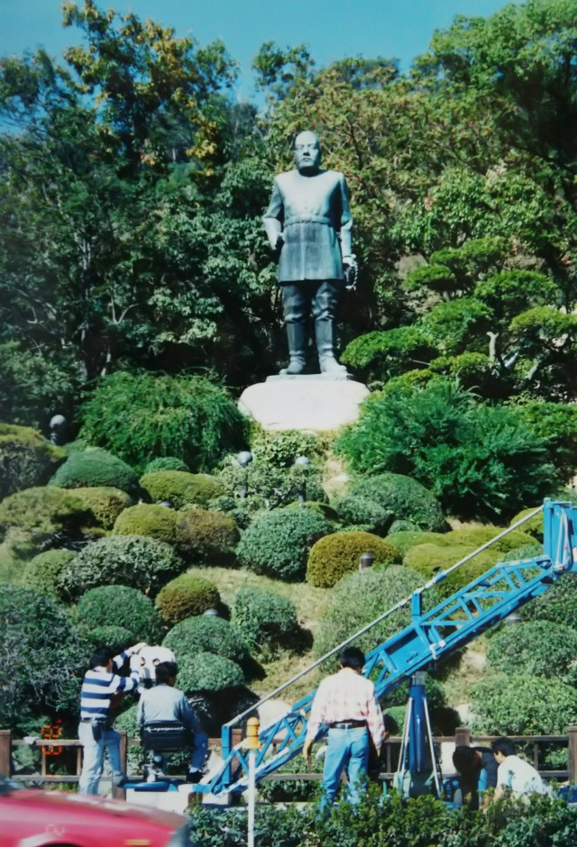
From Ijūin to Kagoshima, I arrived just before noon. The photo shows the imposing statue of Saigō-don, the first Army General Saigō Takamori in uniform, standing tall against the backdrop of Shiroyama Hill in the city. Including its base, it stands 8 meters tall. This statue is one of the masterpieces by Kagoshima-born sculptor Andō Teru, who also created the “Hachikō Statue” in Shibuya. At the time, they were filming something.
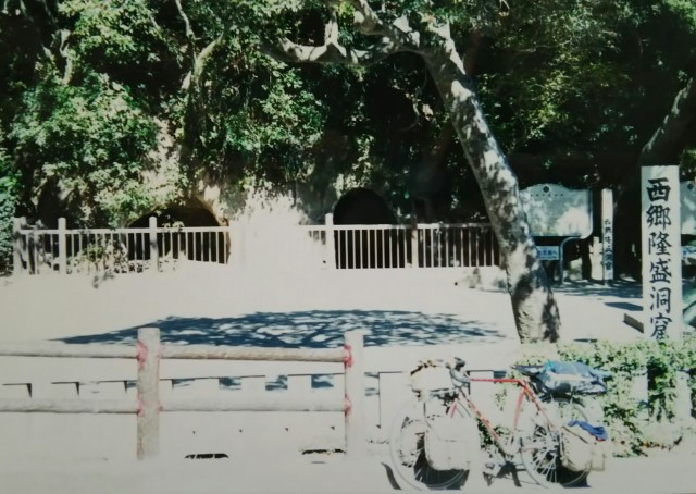
Across the Nippō Main Line, the area around Shiroyama-chō contains many sites connected to Saigō Takamori. Next is the cave where Saigō, pursued by government forces and returning to Kagoshima, is said to have holed up for his final five days while the siege of Shiroyama continued.
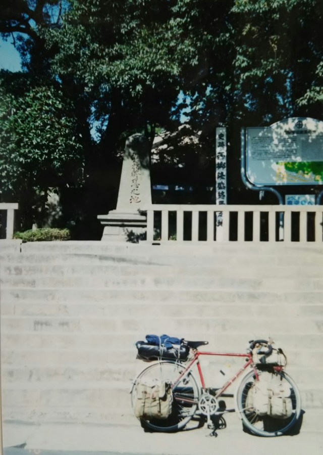
Finally, this is the place where Saigō Takamori met his end. Already wounded by gunfire, Saigō is said to have committed seppuku with the assistance of a second.
伊集院から鹿児島へ、昼前に到着しました。写真は市内の城山をバックにデンと構える西郷どん、制服姿の初代陸軍大将の西郷隆盛像です。土台とも高さ8mあります。この像は鹿児島出身の彫刻家、渋谷の「忠犬ハチ公像」を制作していた安藤照の代表作の一つです。この時は何やら撮影中でした。
日豊本線をはさんで城山町周辺には西郷隆盛のゆかりの地が多くあります。続いては政府軍に追われ、鹿児島に戻った西郷隆盛が城山包囲網の続く中、最後の5日間をこもったといわれる洞窟です。最後は西郷隆盛終焉の地です。すでに銃弾を受けていた西郷隆盛は介錯を得ての自刃といわれています。
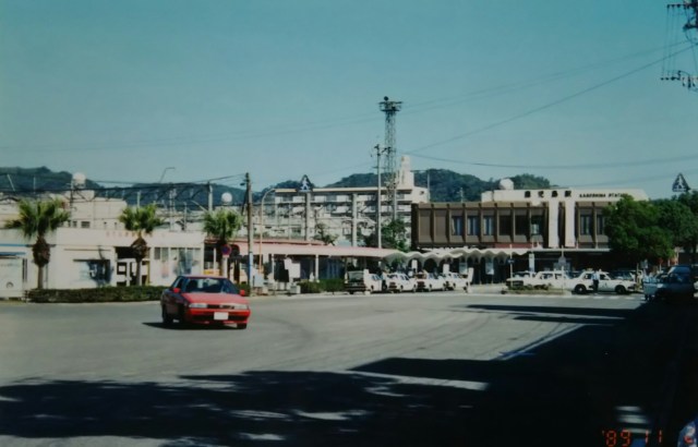
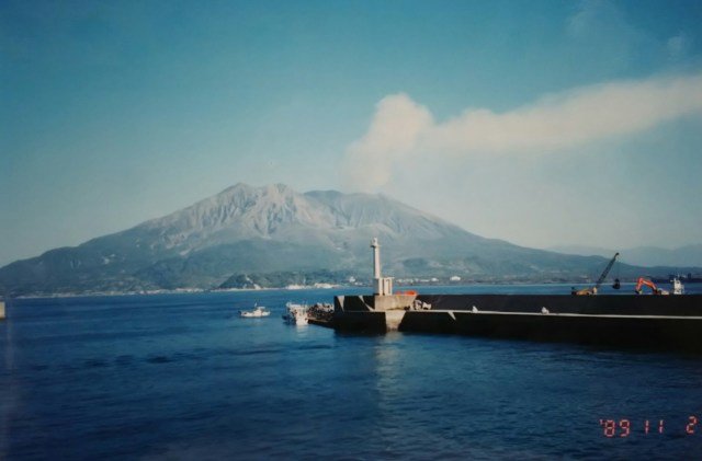
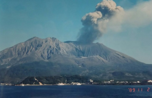
This is Kagoshima Station. Next is Sakurajima as seen from the Kagoshima side. A photo taken from the ferry (¥280) to Sakurajima. A truly active volcano—the color of the smoke changed within minutes.
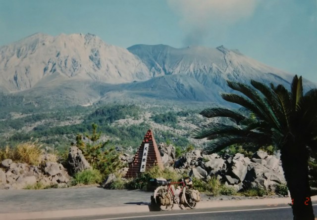
Sakurajima is roughly circular, measuring 12 km east-west and 10 km north-south. An eruption during the Taisho period(1912-1926) connected it to the Osumi Peninsula. We drive along the southern coast of the island. Like around Mount Aso, concrete shelters are dotted along the road. The difference lies in their size and number. Sakurajima’s shelters are small, but they are installed every 200-300 meters, making them numerous.
Heading south along Kinko Bay to Ōdomari in Sata Town. Here, a problem arose!! The private toll road leading to Cape Sata, “Sata Misaki Road Park” (about 8 km), prohibits pedestrians and bicycles, requiring bus use. Moreover, the round-trip bus fare is ¥700, plus a ¥100 viewing fee at the cape. What a pain!
写真は鹿児島駅です。続いて鹿児島側から見た桜島です。フェリー(280円)で桜島へ、船上からの写真です。まさに活火山、数分で噴煙の色が変わりました。
桜島は東西12キロ、南北10キロとほぼ円形です。大正期の噴火で大隅半島と陸続きになりました。島の南を海沿いに走ります。阿蘇山同様に道沿いの所々にコンクリート造りの退避壕があります。違うのは、大きさと数。桜島の退避壕は小さいのですが、2~300mごとに設置され数が多いのです。
錦江湾沿いを南下、佐多町大泊へ。ここで問題発生!! 佐多岬へ通じる私有の有料道路「佐多岬ロードパーク(約8キロ)」が徒歩と自転車の通行禁止、バス利用との事。しかも往復のバス運賃700円、さらに岬の展望料金100円、ナンテコッタイ。

I was the only passenger on the bus, chatting with the driver as we headed toward the cape. After winding up and down the toll road, I arrived at the entrance to the walking path leading to the cape. “Watch out for monkeys,” the driver warned me. “This is the last bus, so don’t be late.”
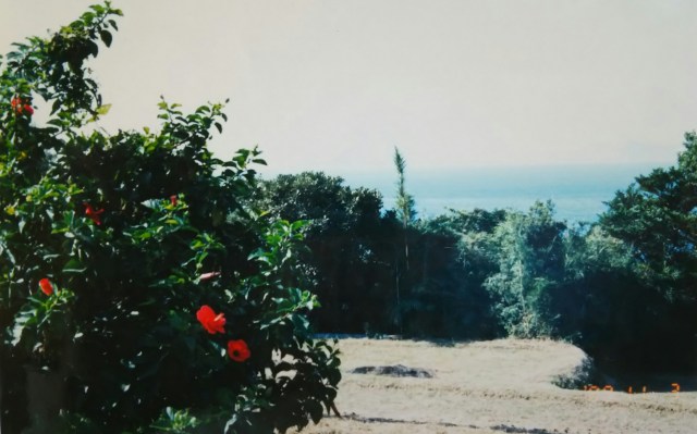
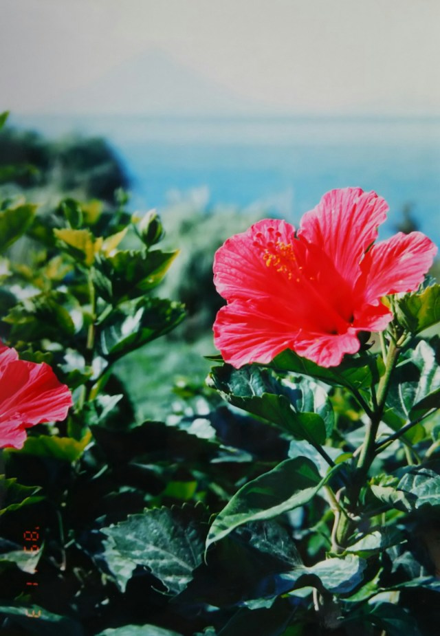
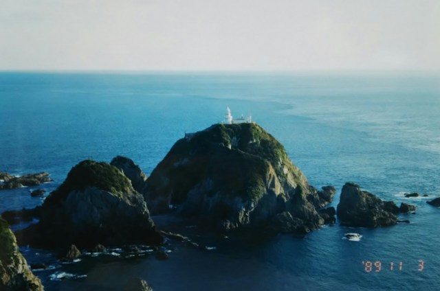
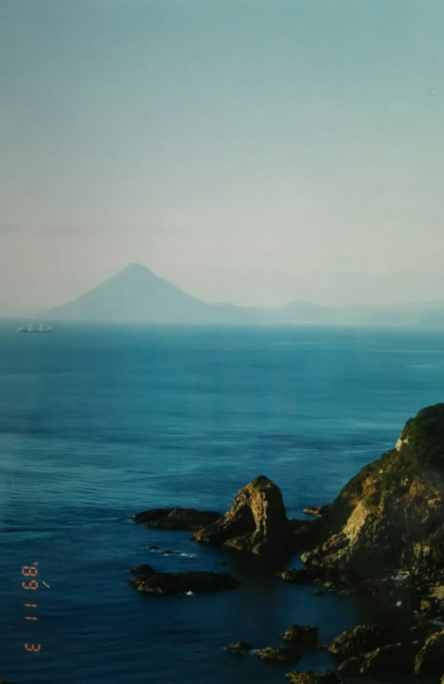
Passing through dense trees with native cycads in the corner of my eye, the view suddenly opened up, and the hibiscus in the photo caught my eye. It was full of tropical charm. And here’s a photo of the cape’s tip. Next is Mount Kaimon on the Satsuma Peninsula, seen from the opposite shore at Sata Cape.
On the return bus, locals finished with their farm work boarded. I couldn’t understand a word of their conversation. They seemed to be speaking in very short sentences. By the time I got back to Ōdomari, the sun had already set. I camped right there at a spot where you could see the lights of Tanegashima Island. Currently, Sata Misaki Road Park is free to access, open to both pedestrians and cyclists.
One more thing: the tofu I bought at a shop in Ōdomari was incredible. It was about half the size of a brick, and they even tied it up with palm fiber rope for me to take home. It was that solid—or rather, the firmest tofu I’ve ever experienced. Its flavor was so rich it matched its satisfying texture (?).
Finally, this photo was taken the day after I returned to Sata Town, with the thought, “I’m heading there now.” Mount Kaimon has a beautiful conical shape no matter where you view it from.
Retracing our route from Sata Town, I took a ferry from Nejime Town’s port across Kinko Bay to Ibusuki on the Satsuma Peninsula, arriving at Yamakawa Town’s port.
My plan was to take a ferry from Kagoshima to Okinawa next, but there was somewhere I wanted to visit first. That was the “Chiran Tokko Peace Museum,” which opened a few years ago. Chiran Town operates this hall because it was once a kamikaze base. Currently, it’s managed by Minamikyushu City, formed in 2007 by the merger of neighboring Chiran, Eicho, and Kawabe towns. So, I put off visiting Ibusuki Onsen and headed towards Chiran, driving through the foothills of Mount Kaimon and camping at Eicho Town’s Sports Park.
This area is famous for tea, producing the largest volume in Japan. Chiran tea is nationally renowned, and I enjoy it myself.
In 1941, an Imperial Japanese Army airfield was constructed in Chiran, where pilot training and education took place. By the war’s end, it became a special attack base, where pilots loaded their aircraft with numerous bombs and rammed enemy ships. The Navy’s special attack base, the Kanoya Air Base, was located on the Osumi Peninsula side in Kanoya, and they conducted operations together.
バスの乗客は私一人、運転手とお喋りしながら岬へ。有料道路のアップダウンを繰り返し、岬へと通じる遊歩道の入り口へ到着。「猿が出るから気を付けて。次が最終便だから遅れないように」と運転手から念を押されます。
自生するソテツ群を横目にうっそうとした木々を抜けると視界が開け、写真のハイビスカスが目に飛び込んできました。南国情緒たっぷりです。そして岬の突端の写真です。続いて佐多岬から見た対岸、薩摩半島の開聞岳です。
帰りのバスには農作業を終えた地元の人が乗ってきました。皆さんの会話がまるでわかりません。どうやら言葉を短くして喋っているようでした。大泊に戻るとすでに日は暮れ、そのまま種子島の明かりが見えるポイントでテント泊。現在、佐多岬ロードパークは無料解放、徒歩でも自転車でも通行可能です。
もう一つ、大泊のお店で買った豆腐がスゴいのです。出てきたのはレンガの半分ぐらいの大きさ、しかも持ち帰り用にシュロ縄でくくってくれました。それほどシッカリしたというか、これまで経験したことのない固い豆腐です。歯ごたえ(?)に負けないくらい味が濃厚でした。
最後は「これから行くからな」と、佐多町に戻った翌日に撮った写真です。開聞岳はどこから見てもきれいな円錐形をしています。
佐多町から来た道を戻り、根占町(ねじめちょう)の港からフェリーで錦江湾を横断、薩摩半島側の指宿、山川町の港へ。
この先、鹿児島からフェリーで沖縄へ行くつもりですが、私にはその前に行きたいところがありました。それはこの数年前にオープンした「知覧特攻平和会館」です。この会館は特攻基地があったということで知覧町が、現在は2007年に近隣の知覧町、頴娃町、川辺町が合併した南九州市が運営管理をしています。ということで、指宿温泉を後回しにして、知覧に向けて開聞岳のふもとを走り抜け頴娃町(えいちょう)の運動公園でテント泊。
この辺りはお茶どころ、生産量も日本一です。知覧茶は全国的に知られており、私も好きです。
1941年、知覧に陸軍の飛行場が建設され、飛行隊員の教育・訓練が行われるようになります。大戦末期になると機体に多くの爆弾を積んで敵艦船に体当たりする特別攻撃、いわゆる特攻基地となります。大隅半島側の鹿屋に海軍の特攻基地、鹿屋航空基地があり作戦を共にしていました。
The Chiran Peace Memorial Hall stands in one corner of the expansive Chiran Peace Park. Inside, thousands of items are displayed, including personal effects and photographs donated by bereaved families, along with materials related to the special attack units. Each letter addressed to family members, akin to a final testament, was deeply moving and brought tears to my eyes. Photography is prohibited inside the hall.
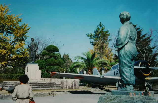
Remnants of former Imperial Army facilities are scattered throughout the town of Chiran. Along the roads, numerous stone lanterns stand in rows; I heard they were donated by the bereaved families of the kamikaze pilots and other supporters. The photo shows a statue of a mother watching her son fly off, with a fighter plane between them.
Rather than heading directly to Kagoshima, I knowingly take the longer route back toward Ibusuki. Along the way, we drive past the base of Mount Kaimon again. It’s said that kamikaze pilots taking off from the Chiran base first used Mount Kaimon as a landmark, then headed south toward the sea in search of enemy ships.
Since the ferry from Kagoshima to Okinawa wasn’t until the following evening, I decided to relax in Ibusuki that day. I spontaneously tried the famous sand baths.
Next time, I’ll circle around Okinawa.
広い知覧平和公園の一角に「知覧特攻平和会館」はあります。館内には遺族から寄贈された遺品や遺影、特攻に関する資料など数千点が展示されています。遺書ともいえる家族に宛てた手紙には、どれも胸を打たれ目頭を熱くさせられました。館内は撮影禁止になっています。
知覧の町の所々に旧陸軍の施設跡が点在しています。また道路沿いには数多くの石灯籠が並んで立っており、特攻隊員の遺族や有志によって寄進されたと聞きました。写真は戦闘機をはさんで飛び行く息子と見守る母親の像です。
直接鹿児島へ向かわず、遠回り承知で来た道を指宿に向けて戻ります。途中、再び開聞岳のふもとを走ります。知覧の基地を飛び立った特攻隊員は先ず開聞岳を目印にし、さらに南の海へと敵艦船を求めて向かったといいます。
鹿児島から沖縄へ向かうフェリー便は翌日の夕方ということで、この日は指宿でノンビリします。飛び入り(?)で名物の砂風呂を体験。
次回、沖縄を一周します。
