Monday, November 6th. The Terukuni Yusen (now Marix Line) ferry departed Kagoshima Port at 6:00 PM. It sailed toward Naha Port in Okinawa, stopping at Amami Ōshima, Tokunoshima, Okinoerabujima, and Yoronjima.
The voyage took a full day, approximately 24 hours. Currently, it also stops at Motobu Port on Okinawa Island, extending the journey to over 24 hours.
Second-class fare: ¥11,800 + bicycle: ¥2,100. The second-class cabin was essentially a large common room, packed almost to capacity with school trip students. Right after boarding, I took a shower and had a beer.
11月6日(月)、照国郵船(現マリックスライン)のフェリーは鹿児島港を夕方6時に出港。奄美大島、徳之島、沖永良部島、与論島に寄りながら沖縄の那覇港へ向かいます。丸一日、約24時間の船旅です。現在は沖縄本島の本部港にも寄るので24時間以上かかります。
二等運賃11,800円+自転車2,100円。二等船室はいわゆる大広間、修学旅行生が一緒でほぼ満員状態。乗船早々シャワーを浴びてビールを一杯。
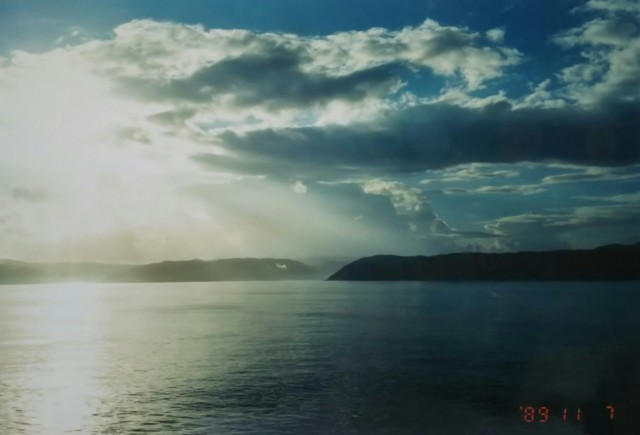
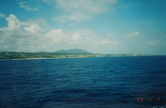

The photos show Amami Oshima in the morning sun, followed by Tokunoshima and Okinoerabu Island.
We encountered delays with cargo at a port along the way, arriving at Naha Port at 8 PM, significantly behind schedule. While aboard, the TV reported the arrival of winter in Hokkaido, but here in Okinawa, unlike Kyushu, it still feels like summer.
Since I arrived at night, we headed straight to a capsule hotel in the city.
I’ll circle Okinawa Island counterclockwise. First, heading south from Naha on National Route 331 towards Itoman.
Southern Okinawa was the site of fierce battles during the Battle of Okinawa in the Pacific War(1941-1945). Many traces tell its story, and it’s designated as the “Okinawa Battle Sites National Park.”
American forces landed on the west coast of central Okinawa and split their advance north and south. The northern area was secured in about two weeks. Meanwhile, the main Japanese forces around Shuri Castle continued to resist, gradually retreating southward under the American offensive. As a result, the American mopping-up operations concluded about three months after the initial landing.
The Battle of Okinawa claimed approximately 200,000 lives. This toll included about 94,000 Japanese soldiers, 94,000 Okinawan civilians, and approximately 12,500 Allied soldiers (primarily American and British). While about 28,000 soldiers were Okinawan natives, most were reportedly hastily assembled troops with minimal training.
Like me, many people have likely seen color footage of the American forces during the Battle of Okinawa. Okinawa has numerous caves called “gama,” which served as natural air-raid shelters where retreating soldiers and civilians hid.
The footage shows U.S. forces firing flamethrowers into these “gama” and throwing grenades inside. It’s also said they fired on people who emerged outside, though I don’t recall seeing that part—perhaps it was cut or edited out. I also remember footage of people, having lost all escape routes, throwing themselves into the sea, the so-called “Banzai Cape” scenes.
写真は朝日の奄美大島、続いて徳之島と沖永良部島です。
途中の港で積み荷に手間取り、予定よりだいぶ遅れて夜8時に那覇港へ時着。乗船中に見たテレビでは北海道の冬の訪れを伝えていましたが、そこは沖縄、九州とも違いまだ夏のように感じます。到着が夜になってしまったので、そのまま市内のカプセルホテルへ。
沖縄本島を反時計回りに一周します。まずは那覇から国道331号線を南下、糸満へ向かいます。
沖縄南部は太平洋戦争における沖縄戦の激戦地です。それらを物語る痕跡も多く「沖縄戦跡国定公園」となっています。
沖縄中部の西海岸に上陸したアメリカ軍は南北に別れて進攻、北部は2週間ほどで制圧されます。一方、首里城周辺の日本軍主力部隊はアメリカ軍の攻勢にジリジリ南へと撤退しながらも抵抗をし続けました。結果、アメリカ軍の掃討作戦が終了したのは上陸から約3ヶ月後になります。
沖縄戦では約20万人の犠牲者が出ました。内訳は日本軍人約94,000人、沖縄住民約94,000人、他に連合国軍側の米英軍人約12,500人。沖縄出身の軍人は約28,000人とされていますが、ほとんどが短期間訓練の寄せ集めといわれています。
私同様多くの人がアメリカ軍の沖縄戦におけるカラーの映像を見たことがあると思います。沖縄には「ガマ」と呼ばれる洞窟が数多くあり、天然の防空壕として撤退を余儀なくされた軍人や民間人が隠れ潜んでいました。映像ではアメリカ軍はその「ガマ」の中に火炎放射器を放ち、手榴弾を投げ込んでいます。さらに外に出てきた人に対しても銃撃したとされますが、さすがにカットされたのか編集されたのか見た覚えがありません。他にも逃げ場を失い、海へ身を投げる様子、いわゆる「バイザイ岬」の映像も記憶にあると思います。

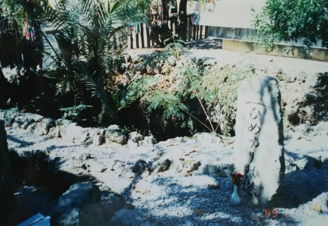

The photo shows the “Himeyuri Tower” in Ihara, Itoman. The memorial monument is located behind the flower offering platform. The second photo shows the cave “Gama” in front of the memorial monument, taken over the fence. It is said to be over ten meters deep, and people used a ladder to enter and exit.
In late March 1945, the “Himeyuri Student Corps” was formed, consisting of 222 students from the Women’s Department of Okinawa Normal School and Okinawa Prefectural First Girls’ High School, along with 18 accompanying teachers. They were assigned to treat and nurse wounded soldiers.
“Himeyuri” originally comes from the kanji “姫百合” (princess lily), combining the names of the girls’ department’s school magazine ‘Shirayuri’ (White Lily) and the First Girls’ High School’s magazine “Otohime” (Princess Princess).
On June 18th, an order to disband the student corps was issued. However, the surrounding area had already been overrun by American forces, leaving them with no escape route. Many suffered casualties.
The cave pictured is identified as the Ihara Third Surgical Cave, where 46 students and 5 teachers from the Himeyuri Student Corps conducted nursing activities.
On June 19, this surgical cave also came under attack with grenades and other weapons. Of the 96 people inside, including wounded soldiers, only 4 students and 1 military doctor ultimately survived.
Behind the “Himeyuri Tower” stands the “Himeyuri Peace Memorial Museum,” completed just six months prior. While the “Chiran Tokko Peace Museum” emphasizes the martyrdom of the kamikaze pilots, the “Himeyuri Peace Memorial Museum” conveys the almost inhuman cruelty of the Battle of Okinawa through the activities of the student corps.
Less than a kilometer east of the Himeyuri Tower along Route 331, in Misaki, stands the memorial tower “Zuisen no Tō” for the nursing corps “Zuisen Student Corps” of the Okinawa Prefectural Shuri Girls’ High School. It takes its name from the school’s location near Shuri Castle’s Zuisen Gate. Other memorials for student corps members also exist in the southern region.
Continuing east on Route 331 for another 2.5 kilometers, the vast grounds of the Okinawa Peace Memorial Park lie on the hills of Mabuni. Lieutenant General Mitsuru Ushijima (later promoted to General), the commander who retreated from Shuri Headquarters, committed suicide in a cave here on June 23rd.
Below the hills of Mabuni, the beautiful sea of Okinawa spreads out. What thoughts must have crossed Lieutenant General Ushijima’s mind as he gazed upon that sea? Maebaru Hill is recognized as the site of the final fierce battle, the “place where the Battle of Okinawa ended.” Furthermore, June 23rd is designated as a holiday in Okinawa, known as “Memorial Day.”
Within the Peace Memorial Park, there are memorials for the war dead from over 30 prefectures, along with numerous memorials dedicated by various organizations. In 1995, the “Peace Memorial Stone” was completed, inscribed with the names of over 200,000 war dead from the Battle of Okinawa. ‘Ishizue’ (foundation stone) apparently becomes “Ishiji” in the Okinawan dialect.
Names of war dead—soldiers, civilians, regardless of nationality—are inscribed and arranged on black granite slabs, about 1.5 meters tall, resembling folding screens.
I visited Okinawa in 1989, before the “Peace Foundation” was completed. However, I did see the black granite slabs lined up. I recall seeing people tracing the engraved names with their fingers, murmuring something. I suspect those black granite slabs were the beginning or model for the “Peace Foundation.” The Memorial Park also contains various other facilities and serves as a place of rest for Okinawa residents.
From here, I headed north along the coastline, camping at Yonabaru Beach overlooking the Pacific.
The road changed to National Route 329, running along the eastern coast through Nakagusuku Village, Gushikawa, Ishikawa, and Kinjo Town. Kinjo Town is home to Camp Hansen, a U.S. military base, and along the roadside, bars and restaurants clearly catering to American soldiers lined the street.
Enjoying the refreshing feeling of two showers in the morning and afternoon, I drove through Ginoza and Henoko. After about 90 kilometers from Yonabaru, I camped at Taira Beach in Higashi Village.
写真は糸満の伊原にある「ひめゆりの塔」です。献花台の奥が慰霊碑です。2枚目の写真は柵越しに撮った慰霊碑前の洞窟「ガマ」です。深さ十数メートルあり、梯子で出入りしていたそうです。
1945年3月末、沖縄師範学校女子部と沖縄県立第一高等女学校の生徒222名、引率教師18名により負傷兵の治療や看護にあたる「ひめゆり学徒隊」が編成されます。
「ひめゆり」のもともとは漢字の「姫百合」で、師範学校女子部の校誌「白百合」と第一高等女学院の校誌「乙姫」を合わせたものでした。
6月18日、学徒隊に解散命令が出されますが、すでに周辺はアメリカ軍に制圧されており、求める逃げ場もないままに多くの犠牲者が出てしまいます。
写真の洞窟は伊原第三外科壕とされ「ひめゆり学徒隊」の生徒46名、教師5名が看護活動をしていた洞窟です。
6月19日、この外科壕も手榴弾などの攻撃を受け、負傷兵を含む総勢96名の内、最終的に生き残ったのは生徒4名、軍医1名でした。
「ひめゆりの塔」の裏手にはこの半年前に完成した「ひめゆり平和祈念資料館」があります。「知覧特攻平和会館」が英霊として重きを置いているとすれば「ひめゆり平和祈念資料館」は学徒隊の活動を通して沖縄戦の無情ともいえる悲惨さを伝えているように感じます。
「ひめゆりの塔」から331号線を東へ1キロ弱、米須に写真の沖縄県立首里高等女学院の看護隊「瑞泉学徒隊」の慰霊碑「ずゐせんの塔」があります。首里高等女学院が首里城の瑞泉門のそばにあったことでこの名が付いています。南部にはその他にも学徒隊の慰霊碑があります。
331号線をさらに東へ2キロ半、摩文仁の丘に広大な敷地を有する「沖縄平和祈念公園」があります。
首里本部から撤退した司令官、牛島満陸軍中将(後に大将)は、6月23日この地の洞窟で自決します。摩文仁の丘の眼下には美しい沖縄の海が広がっています。牛島中将はどんな思いでその海を見たのでしょうか。摩文仁の丘は最後の激戦地として「沖縄戦終焉の地」とされています。また沖縄では6月23日を「慰霊の日」として休日になっています。
平和祈念公園内には30以上の府県の戦没者慰霊碑を始め、団体の慰霊碑も数多くあります。1995年、沖縄戦の戦没者20万人以上の名前を刻んだ「平和の礎(いしじ)」が完成しました。「いしづえ」が沖縄の方言では「いしじ」となるそうです。
高さ1.5mほどの屏風のような黒御影石に軍人、民間人、国籍を問わない戦没者の名が刻まれて並んでいます。
私が沖縄を訪れたのは1989年、まだ「平和の礎」は完成していません。ただし、黒御影石が並ぶようすを目にしていました。刻まれた名前を指で擦りながら何やら語りかけている人の姿を思い出します。おそらく当時の黒御影石が「平和の礎」の始まりかモデルとされたように思います。祈念公園内には他にも様々な施設があり、沖縄県民の憩いの場にもなっています。
この先は海岸線を北上、太平洋を望む与那原ビーチでテント泊。
国道は329号線に変わり、東側海沿いを中城村(なかぐすくそん)、具志川、石川、金城町と走ります。金城町には米軍基地キャンプ・ハンセンがあり、街道沿いにはバーなど米兵向けと一目でわかる飲食店が並んでいます。
午前、午後と2回のシャワー(にわか雨)を「気持ちイイ」と感じながら宜野座、辺野古と走り抜け、与那原から約90キロ、東村(ひがしそん)の平良のビーチでテント泊。


Heading north on Prefectural Route 70, about 60 kilometers from Taira, I aim for Hedo Cape, the northernmost point of Okinawa.
The photo shows Prefectural Route 70 winding through red earth. The constant ups and downs, coupled with the lack of anything noteworthy along the road, make it feel even more grueling. I drove surrounded by dense trees like those in the photo. There’s almost no traffic, just the occasional beat-up car, likely driven by a U.S. Marine on leave. Even after driving for half a day, I hadn’t seen a single traffic light.
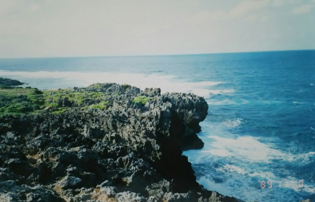
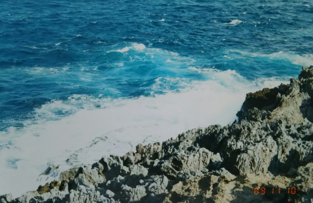
And here is the sea around Hedo Cape, the northernmost point. Just over 20 kilometers across the water to Yoron Island, faintly visible in the distance…
Next time, I’ll head south along Okinawa’s west coast and cross over to a small remote island.
県道70号線を北上、平良から約60キロ先、沖縄の北端、辺戸岬を目指します。
写真は赤土の中を行く県道70号線です。アップダウンが続き、道路沿いにはこれといった物もなく、よりきつく感じます。周囲を写真のようなうっそうとした木々で囲まれた中を走ります。車の通行はほとんどなく、たまに休暇中のアメリカ海兵隊員と思われるオンボロ車とすれ違うぐらいです。半日走っても信号はありませんでした。
そして最北端、辺戸岬周辺の海です。与論島まで海をはさんで20キロちょっと、ボンヤリ見えたような……。
次回、沖縄の西海岸を南下、小さな離島へ渡ります。
