That night’s lodging was at Taiji Station. Just as I was drifting off, I sensed something and woke up to find a flashy, brightly lit bicycle arriving outside the station building. It was 11 PM. “With lights that bright, you should be fine,” I said to the owner of the illuminated bike, a man in his sixties named Mr. M.
Turns out he graduated from the university in my hometown, and even stayed in a boarding house in a town I knew well. We chatted about this and that, and both of us only got 4 or 5 hours of sleep.
“You know the cave bath at Hotel Urashima, right? Morning bath. I’ll take you,” said Mr. M. So, we changed our plans to visit the “Whale Museum” and headed to the neighboring town of Nachikatsuura early in the morning.
Hotel Urashima stands on a small cape facing the Kumano Sea, opposite Katsuura Port. Perhaps because the land route is a detour, a dedicated shuttle boat departs from the port.
The landing stage leads directly to the hotel entrance. Mr. M just gave a quick word at the front desk and walked me straight inside – the “face pass” treatment. He mentioned being the deputy head of a famous local cram school, but it seems he’s also a local dignitary.
First, we took a long elevator up to the annex on the mountain, where he wanted to show me the Pacific Ocean spread out below. We went back down, walked through a long, tunnel-like passageway to the cave bath we were aiming for, and found no one else there.
It was quite spacious, maybe the size of a competitive swimming pool. Pushing through the milky white water, the view opened up, revealing the bright sea.
Mindful of the rocks overhead, I crouched down and submerged myself up to my shoulders. Our conversation echoed within the cave bath, just the two of us.
After parting ways with Mr. M at Nachi Station on the way back to his home in Shingu, I headed toward Nachi Falls on the mountain side.
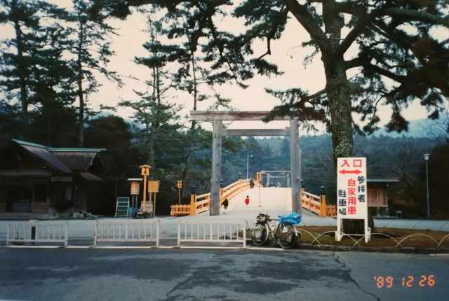
The gentle ascent turned into the toll road (free for bicycles), the “Nachi-san Skyline,” and simultaneously became a steep, winding climb. Even so, Nachi Falls sits at an elevation of less than 300 meters. After a few curves, I reached the entrance. Leaving my bike, I climbed the stairs and saw the impressive shrine office and torii gate of Hiroji Shrine. The Hiroji Shrine is a branch shrine of Nachi Taisha, one of the Kumano Sanzan.
この日の宿は太地駅。寝入りばなに何やら気配を感じて起きると、駅舎の外に派手な電飾のチャリンコがやって来ました。時刻は夜の11時「それだけ明るければ大丈夫ですね」と話しかけた電飾チャリンコの主は60過ぎのオッサン、Mさんです。
聞けば私の住む町の大学を卒業、しかも下宿先も私のよく知る町、ナンダカンダで話しが弾み、二人とも睡眠は4、5時間。
「ホテル浦島の洞窟風呂、知ってるだろ。朝風呂だ、連れてくよ」とMさん。ということで「くじらの博物館」に行く予定を変更、朝から隣町の那智勝浦へ向かいました。
ホテル浦島は勝浦港の向かい側、熊野灘に面した小さな岬に立っています。陸づたいだと遠回りなのか、港から専用の送迎船が出ています。
船着き場の前はそのままホテルの入り口です。Mさんはフロントにひと声かけると、そのまま私を連れてホテル内へ「顔パス」っていうヤツです。Mさん、地元有名塾の塾長代理ということでしたが、どうやら地元の名士でもあるようです。
まずは長~いエレベータで山の上の別館へ、眼下に広がる太平洋を見せたいということです。下へ戻り、トンネル風の長~い通路を歩いてお目当ての洞窟風呂へ、先客はいません。
競泳プールほどでしょうか、かなりの広さです。白濁したお湯をかき分け先へ進むと視界が開け、明るい海が望めます。頭の上の岩に気を配りながら、腰をかかがめて肩までお湯につかります。洞窟風呂に二人だけの会話が響いていました。
新宮の自宅へ戻るMさんと那智駅前で別れ、山側の「那智の滝」へ向かいます。
緩やかな上りは、途中から有料道路(自転車は無料)「那智山スカイライン」に変わると同時につづら折りの急な上りになります。それでも那智の滝の標高は300m足らず、数回のカーブで入り口に到着。自転車を置いて階段を上って行くと「飛瀧神社(ひろうじんじゃ)」の立派な社務所と鳥居が見えてきました。この飛瀧神社は熊野三山の一つ「那智大社」の別宮です。
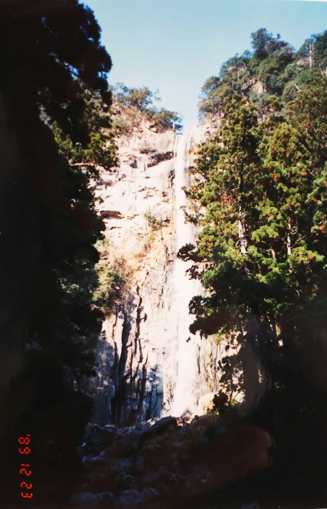
Beyond the torii gate lies Nachi Falls, pictured here. Though called a shrine, it has neither a main hall nor a worship hall; the waterfall itself is the sacred object.
The Kumano mountains have long been revered as sacred sites of nature worship. Nachi Falls, known as the “First Falls” representing the “Forty-Eight Falls of Nachi,” is considered a symbol of this natural faith.
A sign explains its 133-meter drop is “Japan’s tallest single waterfall.” Water volume seems low this season. A sacred rope is visible at the top of the falls. Later, the Nachi Skyline became toll-free and is now part of a prefectural road.
Returning to Route 42 (Kumano Kaido), I head to Shingu. In Shingu, I visit the “Sato Haruo Memorial Museum,” which opened just the previous month.
Sato Haruo debuted in the literary world after being recommended by Tanizaki Junichiro. His talents were diverse; he was active as a poet, writer, and painter from the Meiji to Showa periods. The memorial hall is a reconstruction of his former Tokyo residence, relocated and restored in his hometown of Shingu.
“…Sanma, sanma, sanma—bitter or salty…” This is from Sato Haruo’s poem “Song of the Pacific Saury.” Haruo shared the table with Chiyo, the wife of his close friend Jun’ichirō Tanizaki, and her daughter. At the time, Tanizaki was infatuated with Chiyo’s younger sister, and his marriage had grown cold. It was out of pity for Chiyo that Haruo composed “Song of the Pacific Saury.” Their relationships twisted and turned, and ultimately, Haruo married Chiyo. Inside the museum, various items are displayed, including original manuscripts, first editions, and paintings.
Crossing the Kumano Bridge over the Kumano River brings you into Mie Prefecture. Stay overnight at Kii-Iki Station, just before Kumano.
After passing Kumano, Route 42 departs from the Kisei Main Line and heads into the mountains, approaching its most challenging section: Yanokotoge Pass. Here, the Kii Mountains abruptly drop down to the Kumano Sea. The section of the Kisei Main Line extending toward the sea was a difficult construction project, finally opening in 1959 (Showa 34).
Route 42 descends to Owase through three tunnels: Ōmata, Yumiyama, and Yanokawa. I deliberately take the old road just before the Ōmata Tunnel. I heard National Railway buses used to run here, but the road is now quite rough, seemingly unused by any vehicles. It features old-fashioned brick and cement tunnels, some still unlined. Their width is narrow, and I admire the bus drivers’ skill.
鳥居の先にあるのが写真の那智の滝です。神社といっても本殿も拝殿もなく、滝そのものが御神体となっています。
熊野の山々は古くから自然信仰の聖地とされていました。那智の滝は「那智四十八滝」を代表する「一の滝」と呼ばれ、自然信仰の象徴とされています。
落差133mは「一つの滝の落差としては日本一」と説明書きがあります。この時期、水量は少ないようです。滝の最上部にしめ縄が見えています。その後、那智山スカイラインは無料化され、県道の一部になっています。
42号線(熊野街道)に戻り新宮へ。新宮ではこの前月に開館したばかりの「佐藤春夫記念館」に寄ります。
佐藤春夫は谷崎潤一郎に推挙され、文壇にデビューします。才能は多岐にわたり詩人、作家、画家として明治から昭和にかけて活躍しました。記念館は東京の旧宅を故郷新宮へ移築・復元したものです。
「……さんま、さんま、さんま苦いか塩っぱいか……」佐藤春夫の詩「秋刀魚の歌」です。春夫が一緒に食卓を囲んだのは親友の谷崎潤一郎の妻、千代とその娘。当時、谷崎は千代の妹に恋慕し、夫婦の関係は冷え切っていました。そして千代に憐れみを抱く春夫が作ったのが「秋刀魚の歌」です。彼らの人間関係は二転三転、結果的に春夫は千代と結婚します。館内には肉筆の原稿を始め、もろもろの初版本や絵画が展示されています。
熊野川にかかる熊野大橋を渡るとに三重県に入ります。熊野の手前の紀伊市木駅泊。
熊野を過ぎると42号線は紀勢本線と離れ山側へと進み、最大の難所、矢ノ川峠(やのことうげ)へと向かいます。このあたりは紀伊山地がいきなり熊野灘に落ち込んでいます。海側へ線路を延ばした紀勢本線のこの区間は難工事で、1959年(昭和34年)になって開通しています。
42号線は大又、弓山、矢ノ川と3つのトンネルを抜けて尾鷲へ下ります。あえて大又トンネルの手前で旧道に入ります。以前は国鉄バスが走っていたと聞きましたが、もう走る車もないのか道はかなり荒れています。昔ながらのレンガとセメント作りの隧道、中には素掘りのままのトンネルも。その幅は狭く、バスの運転手のテクニックに感心します。

The photo was taken near Yanogawa Pass (elevation 807m). Rain came and went, clouds swirled. I descended all the way along the Yanogawa River to Owase… well, actually, one spoke on the free side broke midway, so I replaced it. Currently, the old road to Yanogawa Pass remains abandoned and dilapidated, with bridges collapsed.
That night’s lodging was at Funatsu Station, two stops past Owase. The station had no doors, leaving it completely exposed to the elements; it promised to be bitterly cold.
Just before Matsusaka, I camped in a tent for the first time since Shirahama. After a stretch of station stays where I could only boil water and couldn’t properly cook over a fire, I made pork shabu-shabu, hot pot tofu, and a “mizutaki-style anything pot” packed with vegetables. We didn’t forget hot sake to ward off the cold.
Instead of heading towards Ise, we took Route 42 straight to Matsusaka, but we were contemplating things in front of the station. One of our rules was to photograph JR stations on film (an outdated term?) as proof of visiting the prefectural capitals of all 47 prefectures.
I skipped Nagoya since I was stopping there to see the World Design Expo. Next, I’ll take a ferry from Toba to the Atsumi Peninsula. That meant even if I went as far as Tsu, the prefectural capital, I planned to turn back…
写真は矢ノ川峠(標高807m)近く、雨は降ったり止んだり、雲がわいてます。矢ノ川沿いを尾鷲まで一気に下り…… いや、途中でフリー側のスポークが1本折れ、交換しました。現在、矢ノ川峠への旧道は橋が落ちるなど荒廃したまま廃道となっています。
この日の宿は尾鷲の二つ先の船津駅。駅には戸がなく吹きっさらし状態、冷え込みそうです。
松坂の手前で白浜以来の久々のテント泊です。しばらく駅泊が続き、お湯を沸かす程度で思うように火を使う料理ができませんでした。ということで豚シャブ、湯豆腐、野菜たっぷりの「水炊き風なんでも鍋」。日本酒の熱燗も忘れずに、寒さをしのぎます。
伊勢方面ではなく、42号線でそのまま松坂へ向かったものの駅前で考えていました。決め事の一つとして、これまで47都道府県の県庁所在地を訪れた証として JR の駅をフィルムに収めて(死語?)きました。
名古屋は「世界デザイン博覧会」を見学するために寄っているのでパス。この先は鳥羽からフェリーで渥美半島へ渡ります。つまり県庁所在地、津まで行っても引き返すつもりでいたのですが……。
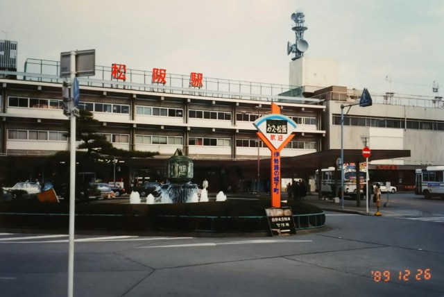
It was 18 kilometers to Tsu, 36 kilometers round trip. I was agonizing over what to do. In the end, I decided to head toward Ise Shrine without going there. On the way from Nagoya to Nara, I had passed through Yokkaichi and Suzuka, leaving Tsu as the only blank section. The photo is of Matsusaka Station, taken after much deliberation.
津まで18キロ、往復で36キロ。どうしようかと悩んでいたのです。結局、行かずに戻る形で伊勢神宮へ向かうことにしました。名古屋から奈良への途中で四日市、鈴鹿と通過しており、津だけ空白の区間となりました。写真は悩んだあげくの松坂駅です。

Ise Grand Shrine is divided into the Inner Shrine and the Outer Shrine, both located south of Ise City. The Inner Shrine (Jingu Daijingu), which enshrines the deity Amaterasu Omikami, has long held deep ties to the Imperial Court and the Imperial Family. The Outer Shrine (Toyouke Daijingu), on the other hand, enshrines Toyouke Omikami, the deity of agriculture.
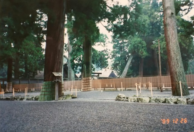
First, the photo shows the Geku. Shrine buildings line the inner side of the fence. The gate was closed, so we couldn’t enter. Continuing south from the Geku leads to the Naiku. The next photo is in front of the Naiku’s main hall. This was December 26th (Tuesday). Perhaps preparing for the New Year’s “first shrine visit,” the Naiku, like the Geku, had its gates closed, preventing entry.
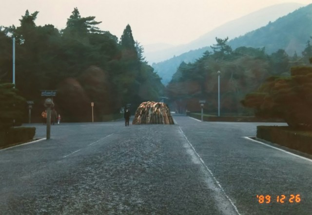
Next is the approach leading to the Inner Shrine. A large pyre of torches is visible in the center. Security guards stand watch, likely to prevent accidents.
The final photo shows the “Uji Bridge,” about 100 meters long, spanning the Isuzu River. Crossing the bridge and turning right leads to the “sazare-ishi” (small stones), also sung about in the national anthem “Kimigayo.” Sazare-ishi refers to clusters of small stones (rocks), and various sizes of these sazare-ishi can be found throughout Japan.
You can see in the photo that only the Uji Bridge looks brand new. At Ise Grand Shrine, the “Shikinen Sengū” ritual relocation of the shrine is performed once every 20 years. In the year of the Shikinen Sengū, all structures, including the main shrine buildings and torii gates, are completely rebuilt.
The first post-war Shikinen Sengū was scheduled for 1949, but Emperor Shōwa, considering the nation still in the midst of post-war reconstruction, instructed that the ceremony be postponed. Officials decided to at least rebuild the Uji Bridge. This year, 1989, marked the third bridge reconstruction since the war.
Four years after the 1949 postponement, the Shikinen Sengū was revived and continues to this day.
While most tourists seem to limit their visit to the Inner Shrine, it is considered proper to proceed from the Outer Shrine to the Inner Shrine. My route—”Main Hall, Approach Path, Uji Bridge”—was the reverse course. As you can see, there were almost no visitors at this time, and it was very quiet.
Leaving Ise Shrine, I headed to Toba to catch the ferry. Again, I couldn’t find a campsite that night and stayed at Futamiura Station on the JR Sangu Line.
Next time, I’ll take the ferry to Cape Irago on the Atsumi Peninsula, then finally circle around the Izu Peninsula before returning to Tokyo.
伊勢神宮は内宮と外宮の二つに分かれ、どちらも伊勢市の南に位置しています。天照大御(あまてらすおおみかみ)を祭神とする内宮(神皇大神宮)は古くから朝廷、皇室との結びつきが深い神宮です。一方の外宮(豊受大神宮)は農耕の神、豊受大御神(とようけのおおみかみ)を祀っています。
まずは最初の写真の外宮へ。垣根の内側に社殿が並んでいます。門が閉ざされていて内に入れませんでした。外宮からさらに南へ行くと内宮となります。次の写真は内宮の正殿前です。この日は12月26日(火)、正月の「初詣で」に備えての準備でしょうか、内宮も外宮と同様に門が閉ざされており、内に入れません。
続いて内宮へとつながる参道、中央に大きな松明(たいまつ)の山が見えます。事故があってはと警備員が立っています。
最後の写真は五十鈴川にかかる長さ100mほどの「宇治橋」です。橋を渡り、右へ進むと「君が代」にも歌われる「さざれ石(細石)」があります。さざれ石とは小さな石の塊(岩)を指し、全国各地に大小様々なさざれ石があります。
写真で宇治橋だけが真新しいのがわかると思います。伊勢神宮では20年に一度「式年遷宮」が行われます。式年遷宮の年には社殿を始め鳥居などすべての建築物が新しく建て替えられます。
戦後最初の式年遷宮は1949年でしたが、昭和天皇は戦後の復興半ばとして、この年の式年遷宮を延期するように伝えます。関係者はせめてもと宇治橋だけ新築しました。この年は1989年、戦後三回目の橋の架け替えが行われたばかりでした。1949年から遅れること4年、式年遷宮は復活して現在に至っています。
観光客のほとんどは内宮のみの参拝で済ませているようですが、外宮から内宮へと参拝するのがよいとされています。私が巡った「正殿、参道、宇治橋」、これは逆コースになります。この時はご覧のように訪れる人もほとんどなく、閑散としていました。
伊勢神宮を後にフェリーに乗るため鳥羽へ向かいます。この日も野営地が見つからず JR 参宮線の二見浦駅泊。
次回、フェリーで渥美半島の伊良湖岬へ渡り、最後に伊豆半島を回って東京へ戻ります。
