The Diamond Ferry (now Ferry Sanfurawa; the Matsuyama port call has since been discontinued) departing from Oita and bound for Kobe arrived at Matsuyama Port in under four hours. It was 8:00 PM, so I stayed overnight at a sauna in the city (¥1,600).
Matsuyama is Shikoku’s largest city, with Iyo Railway’s streetcars running multiple lines. Designated as an “International Hot Spring Tourism City” alongside Beppu, Ito, and Atami, it promotes tourism under the slogan “City of Hot Springs, Castles, and Literature.” The previous year saw the completion of the Seto Ohashi Bridge, making travel to Shikoku quite the trend at the time.
大分発、神戸行のダイヤモンドフェリー(現 フェリーさんふらわあ 今は松山への寄港便は廃止)は、4時間足らずで松山港へ到着しました。時刻は夜8時、そのまま市内のサウナ泊(1,600円)。
松山は四国で一番の大きな街、伊予鉄道の路面電車が複数の路線を走っています。別府、伊東、熱海とともに「国際観光温泉文化都市」に指定されており「いで湯と城と文学のまち」をキャッチフレーズに観光に力を入れています。この前年、瀬戸大橋が完成したこともあり当時は四国への旅行がブームにもなっていました。
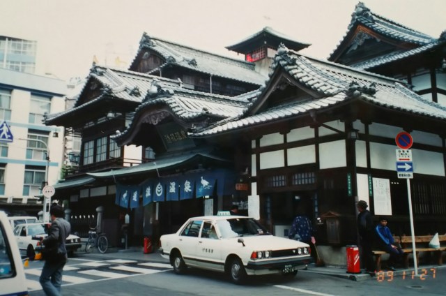
The photo shows the well-known “Dōgo Onsen.” It also appears in Natsume Sōseki’s novel “Botchan.” It is Japan’s oldest hot spring with a history of three thousand years, said to have been used by ancient emperors and Prince Shōtoku. This building was constructed during the Meiji era(1868-1912).
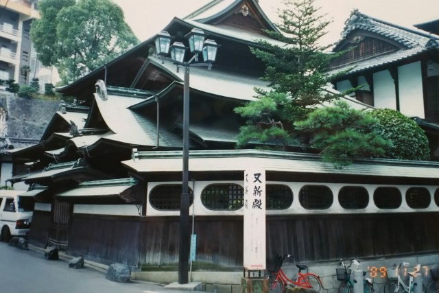
The second photo was taken from the front, moving to the side. It is labeled “Yūshinden,” referring to the imperial family’s private hot spring within Dōgo Onsen. It is known for having been used by Emperor Showa. An admission fee is required, but visitors can see the “Throne Room,” decorated with gold leaf and built in the shoin-zukuri style, as well as the granite bathtub used by His Majesty the Emperor. ‘Yushinden’ apparently means “newly built again.”
Since Dogo Onsen is a public bath, I could have entered, but having sweated profusely in the sauna last night, I decided to just take photos. My mind seemed to be set on the Shimanto River, thinking “I really want to visit this in Shikoku.”
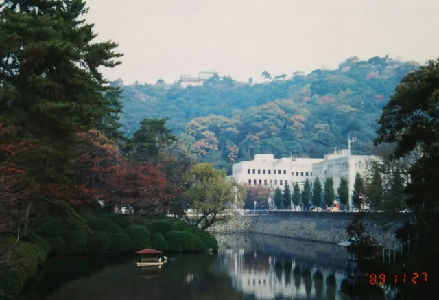
The last photo is of “Matsuyama Castle” on the hill. Its Edo-period reconstructed keep still stands today, making it popular with castle enthusiasts.
From Matsuyama, I traveled counterclockwise around Shikoku. I followed the Yosan Main Line along the Iyo-nada coast, then headed upstream along the Hiji River from Nagahama, camping in Ōzu that night.
Ozu is known as “Iyo’s Little Kyoto,” characterized by its tranquil old townscape centered around Ozu Castle. This historic setting was used as the Meiji-era backdrop for the NHK morning drama “Ohana-han,” where it served as the hometown of the protagonist.
Unfortunately, rain started at night, and it looked like it would get cold. For a chilly night, it was time for hot whiskey – the whiskey given to me by the father of Mr. A, who had been so kind to me in Oita.
The rain cleared before noon, and I headed from Ozu to Uwajima via National Route 56. Leaving Route 56 from Uwajima, I turned inland, crossed three small mountain passes, and arrived in Hiromi Town. The next day, I would join the Shimanto River.
From Hiromi Town, I drove along the Hiromi River, parallel to the Yodo Line. Entering Nishitosa Village, Kochi Prefecture from Matsuno Town, we joined the Shimanto River at Ekawasaki. From here, we descended about 30 kilometers along the river to the mouth at Nakamura (now Shimanto City), where it flows into Tosa Bay.
写真はお馴染みの「道後温泉」です。夏目漱石の小説「坊っちゃん」にも登場します。三千年の歴史を有する日本最古の温泉で、いにしえの天皇や聖徳太子も入湯したといわれています。この建物は明治時代に建てられたものです。
2枚目の写真は正面からの横に回って撮ったものです。「又新殿(ゆうしんでん)」とありますが、道後温泉内にある皇室専用の温泉のことです。昭和天皇が入湯したことで知られています。拝観料が必要ですが、金箔で装飾された書院造りの「玉座の間」や天皇陛下が入った御影石の浴槽などを見学できます。又新殿とは「また新しく出来た」という意味だそうです。
道後温泉は公衆浴場ですから入ることもできましたが、昨夜サウナでたっぷり汗をかいたこともあり、写真だけにしました。気持ちは「四国でぜひ行ってみたい」四万十川に向いていたようです。
最後の写真は丘の上の「松山城」です。江戸時代に再建された天守が現存しており、お城ファンには人気があります。
松山から反時計回りに四国を巡ります。伊予灘の海沿いを予讃本線と並走、長浜から肱川をさかのぼり、この日は大洲でテント泊。
大洲は「伊予の小京都」といわれるように大洲城を中心とした落ち着いた感じの古い町並みが特徴的です。そんな古い町並みを明治の時代設定に利用し、NHK の朝の連ドラ「おはなはん」の主人公の出身地としてロケが行われています。
あいにく夜から雨、冷え込みそうです。寒い夜にはホット・ウイスキー、大分でお世話になったAさんの親父さんからもらったウイスキーの出番です。
雨は昼前にあがり、大洲から国道56号線で宇和島へ。宇和島から56号線を外れ内陸へ、小さな峠を3つ越え広見町に到着。翌日、四万十川に合流します。
広見町から予土線と並走する形で広見川沿いを走ります。松野町から高知県西土佐村に入ると江川崎で四万十川に合流しました。この先、土佐湾に注ぐ中村(現 四万十市)の河口までの川沿い約30キロを下ります。
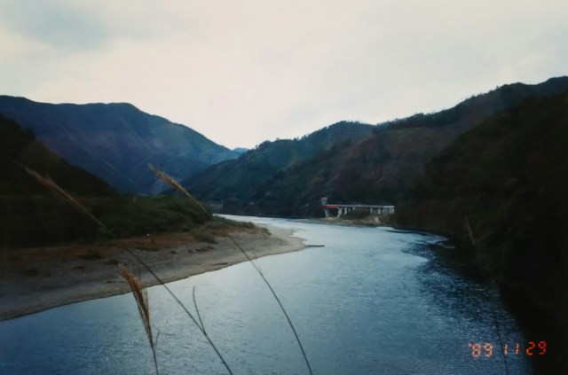
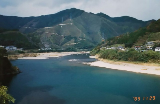
The Shimanto River, with a total length of 196 kilometers, is the longest river in Shikoku and is known as “Japan’s Last Clear Stream.” Its pristine waters are preserved due to the scarcity of dams in its upper reaches and the numerous tributaries flowing into it from the middle to lower reaches.
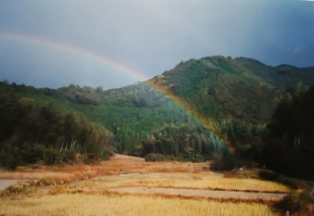
The Shimanto River flows through deep green mountains. Small boats, likely for ayu fishing, are moored. The water level seems a bit low this time of year. The unexpectedly high number of dump trucks passing on the road is a bit tiring. At times like this, I head down to the river and rest on one of the Shimanto’s famous “submerged bridges.” Can you spot the small submerged bridge in the photo? A rainbow arched across the sky, mixed with light rain.
Submerged bridges are built low above the river surface. They are just wide enough for a single car to pass, with no railings—the bridge itself is flat.
Due to its location, Shikoku experiences frequent typhoons and heavy rains, causing rivers to rise rapidly. While the bridge sinks below the current, the smooth, unobstructed surface allows driftwood and debris to flow over it without damaging the structure. Though varying in size, the Shimanto River has 47 submerged bridges. Similar bridges exist on the Yoshino River flowing through Tokushima Prefecture. Those are called “submerged bridges.”
Camping in a tent on the Shimanto River floodplain in Nakamura City. Warming up with cod hot pot.
From Nakamura, back on Route 56 towards Susaki. I drive along the Tosa Kuroshio Railway and the Dosan Main Line.
四万十川は総延長196キロ、四国最長の川で「日本最後の清流」といわれています。上流域にダムが少ないことと中流域から下流域にかけても多くの支流が流れ込むことで清流が保たれています。
四万十川は緑深い山間を流れています。アユ漁でしょうか、それらしい小舟がもやいであります。この時期、ちょっと水量が少ないようです。思いのほか街道を行き交うダンプが多くて少々疲れます。そんな時は川まで下りて、四万十川名物「沈下橋」に腰掛けて休憩します。写真に小さく写る沈下橋が確認できるでしょうか。小雨の混じりの空に虹がかかっていました。
川面から低い位置に作られたのが沈下橋です。橋の幅は乗用車が一台通れるほど、欄干にあたる部分がなく橋そのものが平らです。
四国は場所柄台風や大雨が多く、河川は一気に水位が上がります。流れの下に橋が沈んでしまいますが、引っ掛かりのない平らな橋の上を流木などが流れていくため橋が壊されずにすむのです。大小の違いはありますが、四万十川には47の沈下橋があります。同じような橋が徳島県を流れる吉野川にもあります。そちらは「潜水橋」と呼ばれています。
中村市内の四万十川の河川敷でテント泊。鱈ちり鍋で暖をとります。
中村から再び56号線で須崎へ。土佐くろしお鉄道から土讃本線に沿って走ります。
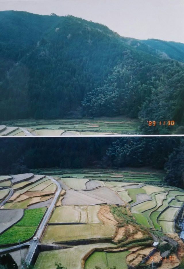
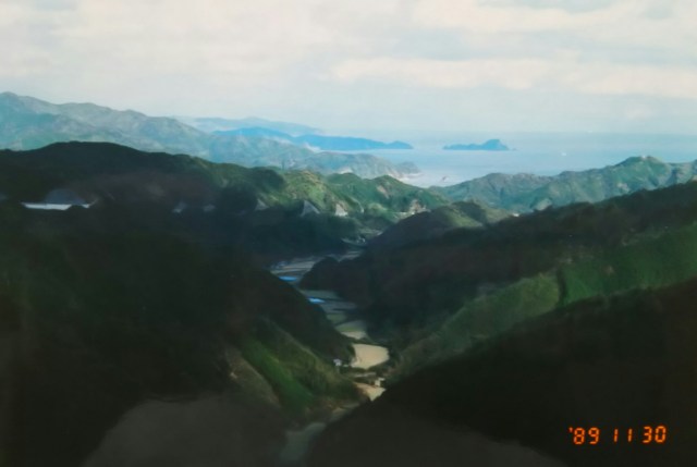
Along the way, I found stunning terraced rice fields nestled in the mountains. Next is the Pacific Ocean (Tosa Bay) seen from the pass. Descending this valley, I reached Nakatosa Town, then drove a little over 10 kilometers further to Susaki. I camped at Nishihama Park, the site of the Tosa Domain’s old artillery battery. The Dosan Main Line runs just 10 meters from my tent.
Next time, I’ll head from Kochi to Tokushima.
途中で山間に見事な棚田を見つけました。続いては峠から見た太平洋(土佐湾)です。この谷を下り中土佐町、さらに10キロちょっと走って須崎へ。土佐藩の砲台跡の西浜公園でテント泊。テントの10m横を土讃本線が走っています。
次回、高知から徳島へ向かいます。
