Day 5 of traveling through Shikoku, Friday, December 1st, arrived in Kochi. First stop: the laundromat. The weather’s been bad lately, so laundry had piled up. Next, checked into a capsule hotel. “Maybe I’ll head out tonight for a drink?” That was the plan when I rode all the way to Kochi. Before grabbing a drink, I’ll explore Kochi’s streets.
♪ “In Tosa’s Kochi, at Harimaya Bridge, I saw a monk buying a hairpin, Yosakoi, Yosakoi”
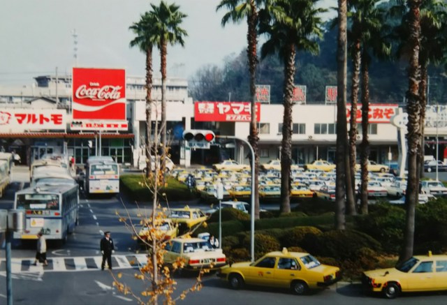
I headed to “Harimaya Bridge,” sung about in the “Yosakoi Bushi” song. From Kochi Station, the streetcar runs straight south along “Harimaya Street.” After about a kilometer, you reach the large “Harimaya Intersection.” Just one street to the right and front of that intersection stood Harimaya Bridge with its red railings.
Today, the red railings have been replaced with concrete, and the original railings, now removed, are displayed underground in the adjacent “Harimaya Bridge Park.” Harimaya Bridge was a private bridge built over a moat by the Harimaya merchant house during the Edo period. A replica of the original bridge, painted bright red, stands in one corner of the park. But was it really such a red bridge?
Walking through Kochi city, I noticed an unusually high number of coral processing and retail shops. Their show windows displayed impressive raw coral logs labeled “from Muroto” and finished products like prayer beads. I hadn’t known coral was a specialty of Kochi.
It’s called “Tosa Coral” and apparently circulates worldwide. Several years ago, news broke about Chinese ships overfishing coral in the Pacific off Tosa Bay.
The Yosakoi Bushi song mentions a monk buying a hairpin, said to be a coral hairpin given as a gift to a town maiden he loved. Afterward, the monk and maiden eloped but were caught, leading to both being exiled. The lyrics of the Yosakoi Bushi seem to be the prologue to that story.
The sun has set considerably. Crossing Harimaya Street, I head to the “Uonotana Shopping Street,” said to have continued since the Edo period. True to its name, it’s lined with fish specialty shops and izakaya. In front of the shops, they’re roasting skewered bonito over burning straw in short-cut drums. It looks like I could enjoy delicious bonito tataki with some tasty sake.
Today, we head from Katsurahama to Cape Muroto. Passing Harimaya Intersection, crossing the Kagami River, and heading south on Prefectural Route 34 for about 10 kilometers, we pass through the town of Urado and emerge at Katsurahama, facing the Pacific Ocean.
四国に渡って5日目、12月1日(金)高知に到着。まずはコインランドリーへ、ここのところ天気が悪くて洗濯物がたまっていました。次にカプセルホテルにチェックイン「今夜は街に出て一杯飲むか」そんなつもりで高知まで走ってきました。一杯飲む前に高知の街を散策します。
♪「土佐の高知の 播磨屋橋で 坊さん かんざし 買うを見た ヨサコイ ヨサコイ」
「よさこい節」に唄われている「播磨屋橋」へ。高知駅前から南へまっすぐ路面電車が走る「はりまや通り」が延びています。1キロほど行くと大きな「はりまや交差点」に出ます。その右手前1本入ったところに赤い欄干の播磨屋橋がありました。
今では赤い欄干はコンクリートに変わり、撤去された欄干は隣接する「はりまや橋公園」の地下に展示されています。播磨屋橋は江戸時代の商家、播磨屋が堀に架けた私設の橋です。公園の一角に当時の橋が真っ赤な色で復元されています。それにしても本当に赤い橋だったのでしょうか。
高知の街を歩いて感じたのは、やたら珊瑚の加工・販売店が多いことです。ショーウインドウに室戸産などと書かれた立派な珊瑚の原木や数珠などの加工品が並んでいました。高知の名産が珊瑚だとは知りませんでした。
「土佐珊瑚」と呼ばれ、世界中に流通しているそうです。何年間か前に土佐湾沖の太平洋で中国船による珊瑚の乱獲がニュースになっています。
よさこい節に坊さんがかんざしを買ったとありますが、珊瑚のかんざしを恋する町娘にプレゼントしたといわれています。その後、坊さんと町娘は駆け落ちしたものの捕まってしまい、二人とも追放されてしまいます。よさこい節の歌詞はそんな話のプロローグのようです。
だいぶ日が暮れてきました。はりまや通りを渡り、江戸時代から続くという「魚の棚商店街」へ。名前の通り魚の専門店や居酒屋が並んでいます。お店の前で、短くカットしたドラム缶の中でワラを燃やし、串刺しにしたカツオを炙っています。美味しいカツオのタタキでウマイ酒が飲めそうです。
この日は桂浜から室戸岬へと向かいます。はりまや交差点を過ぎ、鏡川を渡って県道34号線を南へ10キロほど、浦戸の町を抜けると大平洋に面した桂浜に出ます。


♪“Mimase, let me show you! Opening Urado Bay, the moon’s famous spot is Katsurahama, Yosakoi, Yosakoi!”
Katsurahama, sung about in the Yosakoi song. Mimase is the town facing Urado Bay at the mouth of the Kagami River.
And speaking of Katsurahama, you know it’s the statue of Sakamoto Ryoma, the Tosa domain ronin who was one of the key figures leading to the Meiji Restoration. He stands facing the Pacific Ocean in the familiar pose seen in photos, leaning on one elbow.
The statue was erected in 1928 (Showa 3) through fundraising efforts by local young volunteers. Standing 5.3 meters tall, over 13 meters including the pedestal, you can’t help but look up. Because Ryoma worked alongside Katsu Kaishu to establish the Japanese Navy, this statue was spared from being melted down for metal during the war.
I drive along Tosa Bay from Urado Bridge, heading for Cape Muroto. True to its reputation as the southern land of Kochi, the sunlight feels warm whenever it’s clear. I merge onto National Route 55 connecting Kochi and Tokushima, passing through Aki and driving on to Nahari Town that day.
♪「御畳瀬(みませ) 見せましょ 浦戸を開けて 月の名所は 桂浜 ヨサコイ ヨサコイ」
よさこい節にも唄われている「桂浜」。御畳瀬とは鏡川の河口、浦戸湾に面した町です。
そして桂浜といえばご存知、明治維新へと導いた立役者の一人、土佐藩浪士「坂本龍馬像」です。写真でよく目にする片肘ついたポーズで太平洋を正面にして立っています。
1928年(昭和3年)に地元の青年有志の募金活動により建立されました。像の高さ 5.3m、台座を含めて13m以上、見上げてしまいます。龍馬が勝海舟とともに日本海軍創設に尽力したということで、この像は大戦中の金属供出を免れたそうです。
浦戸大橋から土佐湾沿いを走り、室戸岬を目指します。さすがは南国高知、晴れてさえいれば日差しが暖かく感じられます。高知と徳島をむすぶ国道55号線に合流、この日は安芸を過ぎ、奈半利町まで走行。


Arrived at Cape Muroto before noon. The photo shows the very tip of the cape jutting out into the Pacific Ocean. From the observation deck, you can see 360 degrees (actually more like 330 degrees?) of the Pacific Ocean. On the hill behind stands the lighthouse, and below it is the statue of Nakaoka Shintaro, a Tosa domain ronin like Ryoma. If Ryoma was the leader of the Sea Aid Corps, Shintaro was the leader of the Land Aid Corps.
Erected in 1935 (Showa 10), seven years after the Ryoma statue, this too was built through the efforts of local young volunteers.
Like Ryoma, it faces the Pacific Ocean. Whether intentional or not, both the statue’s size and the pedestal’s height match Ryoma’s statue. Its continued existence means the Shintaro statue also escaped being melted down for war metal during the war.
Heading north along the coastline from Cape Muroto, the sea comes into view on the right. That night, I camped on the beach at Shishikui Town, the southernmost point of Tokushima Prefecture.
Leaving Shishikui Town, I stopped at Hiyoshi’s Ohama Beach, known as a sea turtle nesting site. I visited the “Hiwasa Sea Turtle Museum” near the shore. The museum’s first floor displays stuffed sea turtles from around the world. After watching a video on the second floor, a “Sea Turtle Quiz” awaited visitors.
I decided to challenge it, as getting all 10 questions correct would earn a prize. After having my answer sheet checked by a staff member, I got them all right (sort of?), winning a museum commemorative badge and a substantial amount of dried hijiki seaweed in a bag.
The quiz was elementary school level; anyone could answer it after walking around the museum. With all that, I covered just over 50 kilometers that day, stopping just before Anan. When I rehydrated the hijiki in water, it expanded surprisingly, meaning I’ll have to keep eating it for a while.
昼前に室戸岬へ到着、写真は太平洋に突き出た岬の突端です。見晴台から360度(実際には330度くらい?)太平洋が見渡せます。後の丘の上には灯台、その下にあるのが龍馬と同じ土佐藩浪士「中岡慎太郎像」です。龍馬が海援隊なら慎太郎は陸援隊の隊長です。
1935年(昭和10年)、龍馬像から遅れること7年、こちらも地元の青年有志の活動によって建立されました。龍馬と同じく太平洋を正面にして立っています。龍馬像と合わせたのか、像の大きさ台座の高さともに龍馬像と同じです。現存しているということは慎太郎像も大戦中の金属供出を免れたということになります。
室戸岬から海岸線を北上、視界に入るのは右手の海。この日は徳島県の最南端、宍喰町の浜辺でテント泊。
宍喰町を出発、途中で海亀の産卵地として知られる日和佐の大浜海岸に寄ります。海岸近くの「日和佐うみがめ博物館」を見学、博物館の一階には世界中の海亀の剥製が展示されています。二階で映像を見終えると「海亀クイズ」が待っていました。10問全問正解すると賞品がもらえるというのでチャレンジ。回答用紙を係員にチェックしてもらうと見事(?)全問正解、賞品は博物館の記念バッチと結構な量の袋入りの乾燥ヒジキです。クイズは小学生レベル、博物館を一回り見学すれば誰でも答えられます。そんなこんなでこの日の走行距離は50キロちょい、阿南の手前までの走行となりました。ヒジキを水で戻すと思いのほか量が増え、しばらくの間、食べ続けなくていけないようです。

In Anan City, there was a place I wanted to visit. It was the alma mater of professional golfer Jumbo Ozaki (Masashi Ozaki), Tokushima Prefectural Kainan High School, pictured here.
Tokushima Prefecture is a powerhouse in high school baseball, having produced multiple Koshien championship schools, including Tokushima Commercial High School and Ikeda High School, famed for its “Yamabiko batting lineup.”
In 1964 (Showa 39), Kainan High School, led by pitcher Masashi Ozaki, made its first appearance in the Koshien National Invitational Tournament and, before anyone knew it, won the championship. Though young Ozaki joined the professional baseball team, the Nishi-Nippon Railroad Lions, he left after three years to become a professional golfer. His subsequent achievements remain unmatched: 94 professional tour victories, multiple money titles, and major tournament wins. His career total of 113 victories is the most in world professional golf, and he was inducted into the World Golf Hall of Fame in 2010.
Jumbo Ozaki, who made a brilliant transition from baseball to golf, was also a hero of our generation. Currently, Kainan High School has closed after merging with Hiwasa High School and Shishikui High School.
From Komatsushima to Tokushima. I snapped a photo in front of the station, then drove straight through Tokushima, crossed the Yoshino River, and pushed on nonstop to our destination for the day: the Naruto Strait.
阿南市では寄りたいところがありました。それはプロゴルファー、ジャンボ尾崎(尾崎将司)の母校、写真の徳島県立海南高等学校です。
徳島県は高校野球の強豪県、徳島商業や「やまびこ打線」でお馴染み、池田高など複数の甲子園優勝高校を出しています。
1964年(昭和39年)、ピッチャー尾崎将司の率いる海南高校は甲子園の選抜大会に初出場し、あれよあれよという間に優勝していまいます。尾崎青年はプロ野球西鉄球団に入団したものの3年で見切りをつけ、プロゴルファーに転身。その後の活躍は、プロツアー優勝94勝、賞金王回数、メジャー大会優勝回数、いずれもいまだ破られていません。通算勝利数113回は世界プロツアー最多、2010年には世界ゴルフ殿堂入りをしました。
野球からゴルフへと華麗に転身したジャンボ尾崎は私たち世代のヒーローでもあったのです。現在、海南高校は日和佐高校や宍喰高校と統合されて閉校しています。
小松島から徳島へ。駅前で写真を一枚、そのまま徳島を素通り、吉野川を渡ってこの日の目的地、鳴門海峡まで一気に走ります。


This photo shows Tokushima Station. In the distance to the right, the path leads to Mt. Bizan, Tokushima City’s symbol, standing at about 280 meters above sea level. Next is the Yoshino River. At its widest point, the river spans over 2 kilometers, making it the second widest river in Japan after the Arakawa River.
Then, crossing the “Konomon Toribashi Bridge” to Ōgejima Island. The final photo shows the “Naruto Strait” and the “Great Naruto Bridge.” On the Tokushima Prefecture side is Omojima Island; across the bridge lies Awaji Island in Hyogo Prefecture.
The Naruto Strait is about 1.4 kilometers wide at its narrowest point, connecting the Harimanada of the Seto Inland Sea with the Kii Channel. During spring tides, the difference in tidal height between the two reaches about 1.5 meters. This difference creates fast currents, forming whirlpools that can exceed 20 meters in diameter.
Passing the boarding point for the Uzu-shio Kisen sightseeing boat (tide-viewing boat) north of the island leads to a small park at the island’s edge.
The last photo was taken at that park. Even without a spring tide, the tidal range occurs four times a day, every six hours, creating whirlpools of varying sizes. Boats speeding along the whirlpool currents, others struggling to move forward—even in this photo, you can see a small whirlpool.
That night, I camped on the beach of Ogejima Island, facing the Kii Channel. Next time, I’ll cross from Takamatsu to Shodoshima Island.
写真は徳島駅です。右奥は徳島市のシンボル、標高280mほどの眉山(びざん)へと続いています。続いて吉野川です。川幅は広いところで2キロを超え、荒川に次ぐ広さです。
そして「小鳴門橋」を渡って大毛島へ。最後の写真は「鳴門海峡」と「大鳴門橋」です。こちら徳島県側は大毛島、橋の向こうは淡路島、兵庫県になります。
鳴門海峡は狭いところで幅1.4キロほど、瀬戸内海の播磨灘と紀伊水道をつないでいます。大潮になると両者の潮位の差が1.5mほどになり、その差が早い流れを作り出し、最大で20mを超えるうず潮となります。
島の北にある観潮船(遊覧船)うずしお汽船の乗り場を過ぎると島の端にある小さな公園に出ます。最後はその公園で撮った写真です。大潮でなくても一日4回、6時間後毎に干満差が生じ、大なり小なりうず潮が生じます。うずの流れに乗ってスピードを上げる船、反対になかなか前に進まない船、この写真でも小さなうず潮が確認できます。この日はそのまま紀伊水道を目の前にした大毛島の浜辺でテント泊になりました。
次回、高松から小豆島へ渡ります。
