From Shikoku, I plan to take a ferry from Takamatsu to Okayama Prefecture, the only place in the Chugoku region I haven’t visited yet. While it’s only about 60 kilometers from Naruto to Takamatsu via National Route 11, I intend to stop at “Kotohira-gu Shrine” and “Seto Ohashi Bridge” located west of Takamatsu first. So, I’ll head upstream along the Yoshino River, cross the mountain pass, and enter Kagawa Prefecture.
四国から先は高松からフェリーで中国地方で唯一立ち寄らなかった岡山県へ向かうつもりです。鳴門から高松までは国道11号線で60キロほどと近いのですが、その前に高松より西に位置する「金刀比羅宮」と「瀬戸大橋」へ寄るつもりです。ということで吉野川沿いをさかのぼり、峠を越えて香川県に入ります。
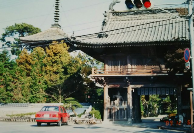
This photo shows Ryōzenji Temple, the first temple of the 88 Sacred Places of Shikoku Pilgrimage, located in Naruto City.
Shikoku is famous for the “Shikoku Pilgrimage” (Ohenro-san), a journey visiting 88 temples associated with Kobo Daishi, Kukai, spanning Awa, Tosa, Iyo, and Sanuki. Originally a monk’s training route, it spread among commoners during the Edo period. While Ohenro-san has its own etiquette and customs, nowadays the specific route or duration is no longer strictly required. It’s apparently enjoying a bit of a boom lately, thanks to the popular “power spots” and “goshuin stamp collecting” trends.
From Prefectural Route 12, I joined National Route 192, running parallel to the Tokushima Main Line. I searched for a campsite for the night in three villages but couldn’t find a suitable spot. Worried it would get too dark, I finally pitched my tent under a large tree in a square I found.
写真は鳴門市内にある四国霊場八十八ヶ所一番寺「霊山寺(りょうぜんじ)」です。
四国といえば阿波から土佐、伊予、そして讃岐と弘法大師、空海にゆかりのあるお寺88ヶ所を巡る「四国巡礼=お遍路さん」が知られています。もともとはお坊さんの修行の道程でしたが、江戸時代になると庶民の間にも広まっていきました。お遍路さんには作法やしきたりがありますが、今では順路や期間を問わなくなったそうです。流行りの「パワースポット」や「御朱印集め」で最近ちょっとしたブームだとか。
県道12号線から国道192号線へ、徳島本線と並走します。3つの集落でこの日の野営地を探しましたが適当な場所が見つかりません。これ以上暗くなってはと、やっと見つけた広場の大きな木の下でテント泊。
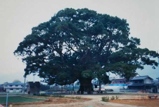
Crawling out of the tent, slightly sleep-deprived from the cold and a dog barking in the night, I discovered a sign I hadn’t noticed yesterday. It read: “National Natural Monument, 1,000-Year-Old ‘Kamo’s Great Camphor Tree’.” It seems I spent the night beneath this giant, a designated natural monument. I took a photo there. It stands about 25 meters tall, and though the angle doesn’t show it well, its width is nearly 50 meters.
Just before reaching Awa-Ikeda town, I changed course northward. Crossing Inohana Pass (elevation 550m), I entered Kagawa Prefecture, the last stop on Shikoku. Less than 20 kilometers from the pass, I arrived in Kotohira Town. Leaving my bicycle behind, I climbed the long approach path leading to Kotohira-gu Shrine.
♪ “Konpira funefune, Oite ni hane kake, Shura shu shu shu, Mawareba Shikoku wa Sanshu…”
Reading the words makes the meaning clear, but when I first heard it as a child, I thought, “What a catchy tune!” This song was sung aboard ships traveling from Osaka to Konpira Shrine and later spread nationwide as a parlor song.
During the Edo period, travel by commoners was generally prohibited, but pilgrimages to shrines and temples like the Ise Pilgrimage or the Konpira Pilgrimage were permitted. Even though it was for religious purposes, the song “Konpira Funefune” seems to express the joy of travel through its rhythm.
Kotohira Shrine is located halfway up Mount Zozusan. The enshrined deities are Ōmononushi-no-kami and Emperor Sutoku, revered as guardians of the sea. The long approach to the main shrine involves climbing stone steps. Souvenir shops and eateries doubling as rest areas line both sides. Passing through several torii gates, you ascend while glimpsing the shrine buildings. Signs along the path mark “XX steps to this point, XX steps to the main shrine,” making your current location undeniably clear. Among the many worshippers, there are also students on school trips.
Occasionally, baskets carrying elderly or physically challenged people are carried horizontally up and down the stone steps.
After climbing for 30 minutes and completing the 785 stone steps, you reach a small plaza—the main shrine. Below lies Kotohira Town, and in the distance stretches the Sanuki Plain.
寒さと夜中に犬に吠えられ少々寝不足の中、テントから這い出すと昨日は気がつかなかった案内板を発見。そこには国の天然記念物、樹齢1,000年「加茂の大クス」とあります。どうやら天然記念物の大木の下で一晩過ごしたようです。そこで写真を一枚。高さ約25m、角度が悪くてそう見えませんが幅は50m近くあります。
阿波池田の街の手前で北へ進路を変えます。猪ノ鼻峠(標高550m)を越えて四国最後の香川県に入ります。峠から20キロ足らずで琴平町に到着、自転車を置いて金刀比羅宮へと続く長い参道を上ります。
♪「金比羅船々(ふねふね) 追風(おいて)に帆かけて シュラシュシュシュ まわれば四国は讃州(さんしゅう)……」
文字にすれば意味が分かりますが、初めて耳にした時には子供心に「何だか調子のいい歌だな」そんな感じでした。この歌は大阪から金比羅参りへ向かう船内で歌われ、後にお座敷歌として全国に広まったといわれています。
江戸時代は庶民の旅行は禁止されていましたが「伊勢詣で」や「金比羅参り」など神社仏閣を訪ねる旅は許されていました。信仰目的とはいえ「こんぴらふねふね」の歌には旅に対する嬉しい想いがリズムとともに表れているような気がします。
金刀比羅宮は象頭山(ぞうずさん)の中腹にあります。祭神は大物主神(おおものぬしのかみ)と崇徳天皇、海の守り神とされています。本宮までの長い参道といっても石段を上ります。両側には土産物屋や休憩所を兼ねた飲食店。いくつか鳥居をくぐり、社(やしろ)を横目に上ります。
所々、参道脇に「ここまで〇〇段、本宮まであと〇〇段」と記されているので否が応でも自分の現在地がわかります。多くの参拝者に混じって修学旅行生もいます。時々お年寄りや体の不自由な人を乗せたカゴが横になって石段を上り下りしています。
上り始めて30分、785段の石段を上り終えるとちょっとした広場、本宮までやって来ました。眼下に琴平町、遠く讃岐平野が広がっています。
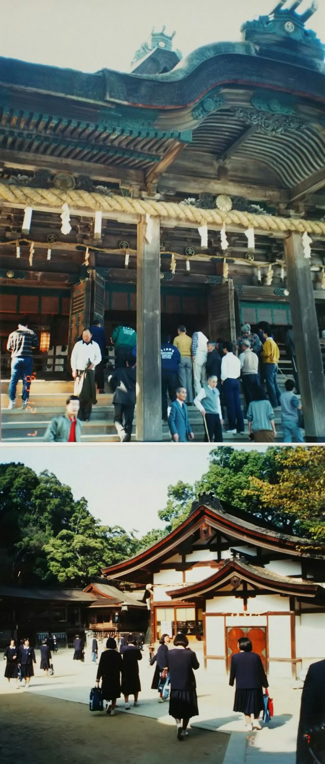
This photo shows the Main Shrine Worship Hall. To the right is the Shrine Amulet Office, and to the left rear is the South Crossing Hall stretching from the Main Shrine to the Mihozuhime Shrine. Mihozuhime is the consort of Ōmononushi.
Climbing further to the Inner Sanctuary adds up to 1,368 steps. That was enough for me; I decided to head back down.
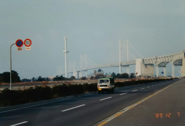
From Kotohira Town to Marugame, then on to the “Seto Ohashi Bridge” in Sakaide. Completed in 1988, the year before, it was the first of the three “Honshu-Shikoku Bridge” crossings currently in use. The bridge spans five islands, large and small, with a total length of about 13 kilometers. The upper deck is for automobiles, the lower for railways, connecting here with Kurashiki in Okayama Prefecture.
写真は本宮拝殿です。続いて右に神札授与所、左奥は本宮から三穂津姫社へと伸びる南渡殿です。三穂津姫は大物主神の后(きさき)です。
ここからさらに奥の院まで上ると合計1,368段。もう十分、このまま下ることにしました。
琴平町から丸亀、そして坂出の「瀬戸大橋」へ。この前年の1988年、現在ある3つの「本四架橋」のうち一番最初に完成しました。大小5つの島にわたって橋は架けられ総延長13キロほど。上が自動車道、下が鉄道の構造になっており岡山県倉敷との間をつないでいます。
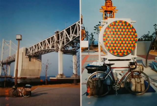
The area near the bridge piers facing the Seto Inland Sea is the Seto Ohashi Memorial Park, featuring monuments and other installations. The photo below was taken in that park. On the right is a cross-section of the bridge’s main cable; its thickness is evident when compared to the bicycle. That night, I camped on Goshikidai, a small hill straddling Sakaide and Takamatsu, with a view of the Seto Ohashi Bridge.
The strong wind from last night became a tailwind, and I reached Takamatsu in about an hour. While its population is surpassed by Matsuyama, Takamatsu, being closer to the Kansai region as exemplified by the former JNR Uta-Kō ferry, can be considered the gateway to Shikoku.
First stop: the coin laundry. While the laundry ran, I got a haircut at the barber shop (¥1,500). I sent postcards and thank-you gifts (udon is the typical Kagawa specialty, but for some reason I chose soba) to people who helped me along the way. After that, I checked into a sauna for a quick soak, strolled around the city until evening, and had a drink. It was a clean and relaxing day.
Before crossing from Takamatsu to Okayama, I visited Shodoshima Island, the setting for the film “Twenty-Four Eyes.” Shodoshima is in Kagawa Prefecture, meaning Shodoshima is the final stop in Shikoku.
Boarded the first ferry of the morning. Even though the population has halved since its peak, Shodoshima still had over 30,000 residents back then, so ferry services weren’t infrequent.
The journey from Takamatsu Port to Tonosho Port on Shodoshima takes about an hour. During that time, I must have dozed off in my seat without realizing it. Truth be told, I was sleep-deprived, thanks to last night’s sauna nap room. Unlike capsule hotels, saunas have large communal rooms where you sleep among others. Snoring, teeth grinding, and even flatulence made it absolutely dreadful.
Shodoshima is the hometown of Sakae Tsuboi, author of the novel “Twenty-Four Eyes.” The movie based on the novel was actually filmed here on Shodoshima. It depicts the interactions and lives of a teacher and students spanning the pre-war, wartime, and post-war periods. First, we headed to the “Cape Branch School,” the setting for the story.
Back in my elementary school days during the 1950s, every summer vacation, a screen would be set up in the schoolyard for movie screenings. Not just children, but adults from the neighborhood would invite each other to come watch. Before TVs became common in homes, movies were the center of entertainment. Tokyo nights weren’t as bright as they are now, so we could enjoy the movies perfectly well in the schoolyard.
Though, to be honest, the adults were the ones most engrossed in the films. Preschoolers and younger elementary students would get bored and go play on the playground’s monkey bars or in the sandbox.
Besides “Twenty-Four Eyes,” I remember seeing “The Burmese Harp,” “Non-chan Rides the Clouds,” and later, in upper elementary, “Nyan-chan.” Of course, it wasn’t just serious films; I also recall the animated feature “The Legend of the White Snake” and the monster movie “Godzilla.”
Both “The Burmese Harp” (1985) and “Twenty-Four Eyes” (1987) were remade.
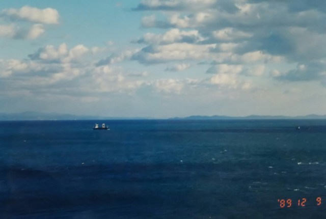
Tosho Port is on the west side of Shodoshima Island. We drove along the coastline to the branch school located at a cape on the island’s east side. Being an island in the Seto Inland Sea, even when the wind was somewhat strong, the warmth of the sunlight made you forget it was December.
瀬戸内海に面した橋げた付近は「瀬戸大橋記念公園」になっており、モニュメントなどがあります。下の写真はその公園で撮ったものです。右は橋のメインケーブルの断面、自転車と比べると太さがわかります。この日は坂出と高松にまたがる小高い丘、五色台でテント泊、瀬戸大橋が見えています。
昨夜からの強風は追い風となって一時間ほどで高松へ到着。人口こそ松山にゆずるものの旧国鉄時代の宇高連絡船に代表されるように関西圏に近い高松は四国の玄関といえます。
まずはコインランドリーへ。洗濯している間に床屋でカット(1,500円)、道中お世話になった人へ絵ハガキとお礼の品(香川といえばうどんですが、何故かそば)を送ります。その後サウナにチェックインしてひとっ風呂、夜まで市内を散策、そして一杯。クリーン&リラックスの一日でした。
高松から岡山へ渡る前に、映画「二十四の瞳」の舞台となった小豆島を訪ねます。小豆島は香川県、つまり四国の最後は小豆島ということになります。
朝イチのフェリーに乗船。ピーク時から半減したといっても当時の小豆島の人口は3万人を超えており、フェリーの便数も少なくありません。高松港から小豆島の土庄(とのしょう)港まで約一時間。その間、いつの間にか椅子に座ったまま寝てしまいました。実は寝不足、その原因は昨夜のサウナの仮眠室です。カプセルホテルと違い、サウナは大広間で他人に混じって寝ることになります。イビキに歯ぎしり、はてはオナラと最悪だったのです。
小豆島は小説「二十四の瞳」の著者、壺井栄の故郷です。その小豆島で実際に映画のロケが行われました。戦前から戦中そして戦後にかけての先生と生徒のふれあいと生きざまを映しています。まずは舞台となった「岬の分教場」へ。
私の小学生時代、昭和30年代には夏休みになると学校の校庭にスクリーンを仕立てて映画大会を催していました。子供だけでなく隣近所大人も誘い合って映画を鑑賞しに行ったのです。まだ一般家庭にテレビが普及する前、映画は娯楽の中心だったのです。今ほど東京の夜も明るくなく、学校の校庭で十分に映画が楽しめました。もっとも映画に夢中なのは大人の方で未就学児童や低学年の生徒は映画に飽きると校庭にある鉄棒や砂場で遊んでいました。
私が覚えているのは「二十四の瞳」のほかに「ビルマの竪琴」、「ノンちゃん雲に乗る」、高学年になって観たのが「にあんちゃん」そんなところでしょうか。もちろんお堅い映画だけでなく、長編アニメ「白蛇伝」、怪獣映画「ゴジラ」なども記憶にあります。
「ビルマの竪琴」は1985年、「二十四の瞳」は1987年、ともにリメイクされています。
土庄港は小豆島の西、島の東に位置する岬の分教場まで海岸線を走ります。さすがに瀬戸内海に浮かぶ島、風が多少強くても日差しの暖かさは12月だというのを忘れさせてくれます。

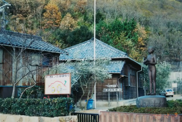
The first photo is of Takamatsu Station. Next is the Seto Inland Sea, with skies like these and wind blowing. And then the branch school at the cape that served as the film’s setting. Filming actually took place here.
This is the Taura Elementary School, built during the Meiji period. It later became the Taura Branch School of Nouma Elementary School and closed in the 1960s. The classrooms still contain desks and an organ used before the war, with the teachers’ quarters adjacent.
Leaving the branch school, we headed to the southeastern tip of the island, Ōkado-no-hana Cape. Across the Harimanada Sea, Awaji Island and the Naruto Bridge are visible. Perhaps drawn by Shodoshima’s warmth, we decided to spend another day exploring the island.
Shodoshima is said to be the birthplace of olives in Japan, and olive groves can be seen all over the island. It is also famous for its soy sauce production, continuing since the Edo period, and its hand-stretched somen noodles.
On this day, I first visited the “Marukin Soy Sauce Memorial Hall,” a converted factory, to learn (?) about the history and manufacturing methods of soy sauce. The admission fee was \200, and as a souvenir, we received a small bottle of Marukin Deluxe Soy Sauce (100ml).
The Kimpira Shrine’s crest is “Marukin,” as seen on the lanterns and talismans within the shrine grounds, which feature a circle with a gold character inside. The company name “Marukin Shoyu” might derive from Kimpira Shrine.
I drove around the northern part of the island, gazing at the mountain range of Hoshigajo Mountain (817m) in central Shodoshima. In the Koumi district, large stones quarried from the mountains about 400 years ago for the reconstruction of Osaka Castle but never shipped remain in place. They are designated as a Kagawa Prefecture historic site under the name “Osaka Castle Construction Remnant Stones.”
Circling the island offers excellent views of the islands of the Seto Inland Sea, Awaji Island, Shikoku, Honshu, the Seto Ohashi Bridge, and above all, the constant flow of passing ships. Shodoshima is right in the middle of the Seto Inland Sea.
最初の写真は高松駅です。続いて瀬戸内海、ご覧のような空で風がありました。そして映画の舞台となった岬の分教場です。実際にここで映画のロケが行われました。
明治期に建てられた田浦尋常小学校です。その後、苗羽(のうま)小学校田浦分校となり、昭和40年代に閉校となりました。教室には戦前に使われていた机やオルガンなどが置かれており、隣接して教職員の宿舎があります。
分教場を後に島の南東端、大角ノ鼻(おおかどのはな)岬へ。播磨灘を隔てて淡路島と鳴門大橋が見えます。小豆島の暖かさにひかれたのか、もう一日島を巡ることにしました。
小豆島は日本のオリーブ発祥の地といわれており、島のアチコチにオリーブ畑が見られます。その他、江戸時代から続く醤油造りや手延べ素麺が有名です。
この日はまず工場を改装した「マルキン醤油記念館」で醤油造りの歴史と製造法を学び(?)ます。入場料200円、記念品として小さなマルキンデラックス醤油(100ml)がもらえました。
金刀比羅宮の境内の提灯やお守りには丸に金の字が記されているように金比羅さんの紋はマルキンです。マルキン醤油の社名は金比羅さんに由来しているのかも知れません。
小豆島の中央には星ヶ城山(標高817m)連山、そんな山並みを眺めながら島の北側を回ります。小海地区には約400年前、大阪城再建のために山から切り出されものの船積みされなかった大きな石がそのまま残されています。「大阪城築城残石」として香川県の史跡に指定されています。
島を一周すると瀬戸内海の島々を始め、淡路島、四国、本州、瀬戸大橋、そして何より行き交う船がよく見渡せます。小豆島は瀬戸内海のドマンナカです。
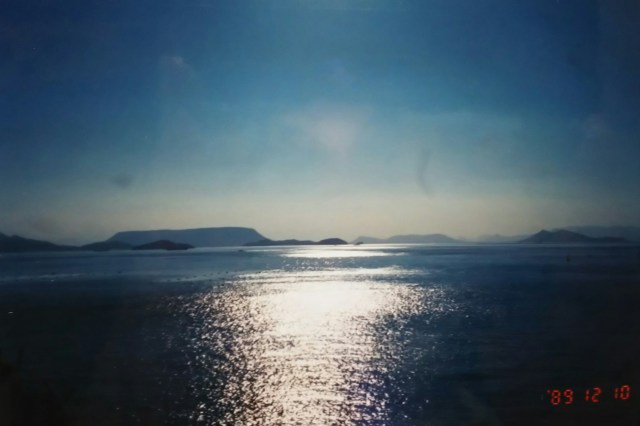
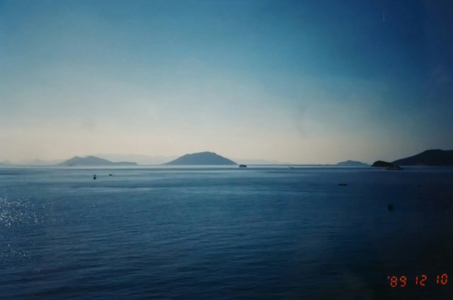
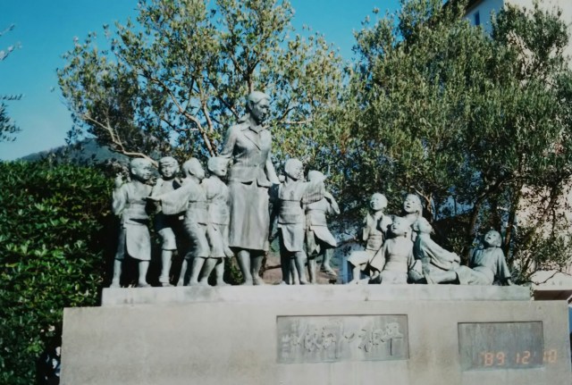
There was almost no wind that day. The photo shows the Seto Inland Sea in such a calm state. Finally, here is the “Statue of Peace,” modeled after the teacher and students from the movie “Twenty-Four Eyes.” It stands in a park near Tonosho Port. The next morning, I boarded the ferry bound for Okayama. That night, I camped in a tent at that park.
Next time, I’ll ride from Okayama to Ako, Himeji, and Kobe.
この日はほとんど風がありませんでした。写真はそんなナイだ状態の瀬戸内海です。最後は映画「二十四の瞳」の先生と生徒をモデルにした「平和の群像」です。土庄港のそばの公園にあります。翌朝、岡山行きフェリーに乗ります。この日はその公園でテント泊。
次回、岡山から赤穂、姫路、神戸と走ります。
