Today, I plan to stop by Miyajima in Aki before heading to Kintaikyo Bridge in Iwakuni. The distance is only about 50 kilometers, so I’ll take it easy.
この日は「安芸の宮島」に寄ってから岩国の「錦帯橋」へ行くつもりです。移動距離は約50キロと短く、ノンビリと行きます。
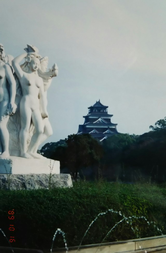
This photo shows Hiroshima Castle. It was built by Mōri Terumoto in the late Azuchi-Momoyama period. The castle collapsed and burned down during the atomic bombing, serving as a landmark at the time, and was restored after the war. The actual hypocenter was about one kilometer south of the castle, near the Atomic Bomb Dome. I took this photo with the statue beside the moat on the morning of my departure.
From Hiroshima, take Route 2 for about 20 kilometers. Pass JR Miyajimaguchi Station on your right, then turn left at the traffic light to reach the ferry terminal for Miyajima (Itsukushima). There are two ferries: one operated by JR and another private one. Both cover the roughly 2-kilometer route to Miyajima in just over 10 minutes and charge the same fare.
写真は広島城です。安土桃山時代の末期に毛利輝元によって築城されました。原爆投下の際の目印となり倒壊・焼失、戦後に復元されたお城です。実際の爆心地はお城から1キロほど南で原爆ドームの近くです。出発の朝、お堀の横の像と一緒に撮りました。
広島から2号線を20キロほど、JR 宮島口駅を右に見て信号を左に曲がれば宮島(厳島)行きのフェリー乗り場です。JR ともう一つ、二つのフェリーがあり、宮島まで約2キロの航路を10分ちょっと、どちらも同じ料金です。
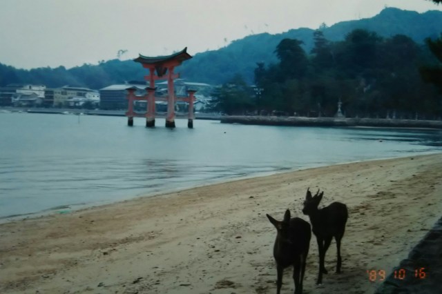


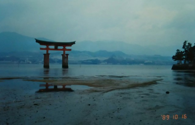
The photo shows Itsukushima Shrine’s large torii gate, with the tide quite low. Deer are messengers of the gods, and Miyajima, like Nara Park, has many wild deer. Next is Itsukushima Shrine’s corridor; the view we’re used to seeing is the gate floating in the sea.
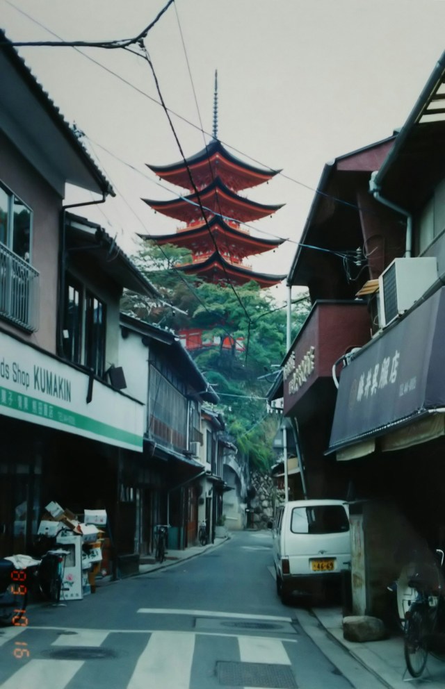
Momijidani Park, deep within the shrine grounds. The autumn colors are still a ways off. Next is the five-story pagoda of Toyokuni Shrine, a subsidiary shrine next to Itsukushima Shrine, photographed from the Machiya Street. The street one block to the right is the main street, Kiyomori Street, lined with restaurants and souvenir shops. Finally, the great torii gate once more. As time has passed, the tide has receded a bit more. At low tide, you can apparently walk right up to the base of the torii.
Itsukushima Shrine was founded during the Asuka period. The island features Mount Misen (535m) at its center, making it an island of mountain worship. Later, under the patronage of Taira no Kiyomori, the shrine was developed into its present form. The shrine grounds contain many National Treasure structures and were registered as a World Heritage Site in 1996.
Despite being the same island, it has two names: Miyajima and Itsukushima. Miyajima is the affectionate name, meaning “the island with the shrine.” Itsukushima is the more formal name, emphasizing its religious significance. Miyajima is the common name. Before the war, the town on the island was called Itsukushima-cho. It was changed to Miyajima-cho in 1950 but is now incorporated into Hatsukaichi City.
The term “Japan’s Three Scenic Views” is said to have become widely established during the Edo period. Visiting all three locations—Matsushima in Mutsu (Miyagi), Amanohashidate in Tango (Kyoto), and here, Miyajima in Aki (Hiroshima)—means one of my pre-departure goals was achieved.
Returning by ferry, I took Route 2 again. About 7 kilometers from the prefectural border with Yamaguchi Prefecture, at Ose River, I arrived at Kintaikyo Bridge.
写真は厳島神社の大鳥居、だいぶ潮が引いています。鹿は神の使い、宮島にも奈良公園と同じく多くの野生の鹿がいます。次は厳島神社の回廊、ふだん見慣れているのは海に浮かんでいる画面(えづら)です。
神社の奥の紅葉(もみじ)谷公園。紅葉にはまだまだです。続いて厳島神社のお隣の末社、豊国神社の五重塔、町家通りから撮った一枚です。一本右の通りがメインストリートの清盛通り、そちらは飲食店や土産物屋がズラリと並んでいます。最後にもう一度、大鳥居です。時間が経過した分だけ、少し潮が引いています。干潮時には鳥居の下まで歩いて行けるそうです。
厳島神社は飛鳥時代に創建されました。島の中央に標高535mの弥山(みせん)があり、山岳信仰の島でした。その後、神社は平清盛の庇護のもと整備され、現在の形になります。神社内には国宝の建造物も多く、1996年には世界遺産に登録されています。
同じ島なのに宮島と厳島の二つの呼び名があります。「お宮(神社)のある島」ということで親しみを込めて宮島。信仰に重きを置き、改まって呼ぶと厳島となります。通称が宮島ということです。戦前の島の町名は厳島町、1950年に宮島町に変更されますが、現在は廿日市市に編入されています。
「日本三景」が一般に定着したのは江戸時代だそうです。陸奥(宮城)の松島、丹後(京都)の天橋立、そしてここ安芸(広島)の宮島と三ヶ所をすべて回り、これで出発前の目的の一つがクリアされました。
フェリーで戻ると再び2号線を行きます。山口県との県境、小瀬川から7キロほどで錦帯橋へ到着しました。

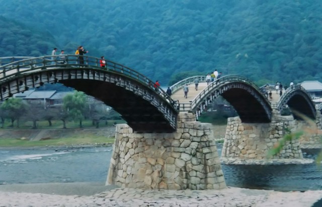

This is the Kintaikyo Bridge, with its beautiful form spanning the Nishiki River. It is an arch bridge built by the Iwakuni Domain in the early Edo period. The bridge is said to have been named Kintaikyo after the Nishiki River. Behind it is Mount Yokoyama, and the solitary structure is the keep of Iwakuni (Yokoyama) Castle. It was restored in a slightly shifted position to be visible from the base of the mountain. The slightly indented part on the left mountain is the ropeway’s mountain station; the boarding area is beyond the bridge. Souvenir shops line the right side of the bridge.
As evident from this layout, the bridge served a vital role connecting the castle to the castle town on the opposite bank. However, heavy rains and floods frequently washed it away.
Consequently, the Iwakuni feudal lord ordered his retainers to build a bridge resistant to floodwaters. A suspension bridge, unaffected by the river’s flow, was considered, but the river was too wide. The solution devised was a five-arch bridge connected by stone foundations.
The bridge was washed away by a typhoon in 1950. It was rebuilt in 1953 using the same Edo-period technique of mortise and tenon joints, without a single nail. A toll is charged to cross the bridge, with the proceeds going toward its maintenance and repairs.
Heading upstream along the Nishiki River, away from the city center, and taking a sharp left turn brings you to the opposite side of Yokoyama. Continuing further leads to the Shinkansen’s Shin-Iwakuni Station. The station area has nothing around it, making it suitable for tent camping.
Next time, I head from Yamaguchi to Akiyoshi Cave.
錦川に架かる美しいフォルムの錦帯橋です。江戸時代の前期に岩国藩によって架けられたアーチ橋です。錦川から錦帯橋という名がついたそうです。後ろは横山、ポツンとあるのが岩国(横山)城の天守です。麓から見える位置にズラして復元されました。左端の山のちょっと凹んだ部分がロープウェイの山上駅、橋を渡った先に乗り場があります。橋の右側には土産物屋が並んでいます。
この位置関係でわかるように橋にはお城と対岸の城下町とを結ぶ大事な役目がありました。ところが大雨、洪水で橋は度々流されます。そこで岩国藩主は家来に洪水に流されないような橋を造るよう命じます。川の流れに影響されない吊り橋も考えられましたが川幅が広すぎました。そこで考えられたのが石積みの土台でつなぐ5連のアーチ橋でした。
1950年に橋は台風で流失し、53年に一本の釘も使わない組み木の手法によって江戸時代そのままに再建されました。橋を渡るには渡橋料がかかり、それらは橋の保全・修理費に充てらています。
市内から遠ざかるように錦川沿いを上流へ、左に大きく曲がると横山の反対側、さらに進むと新幹線の新岩国駅に出ます。駅周辺には何もなく、テント泊におあつらい向きでした。
次回、山口から秋芳洞へ向かいます。
