My journey back from Tokyo to the Sea of Japan coast was primarily aimed at the Noto Peninsula. I’d long wanted to visit it. I drove along National Route 8, which connects Itoigawa to Niigata and Kyoto.
The first sight was Oyashirazu, a sheer cliff where the Hida Mountains abruptly drop into the Sea of Japan. Until the Meiji era, when the national highway and Hokuriku Main Line opened, it was considered the most treacherous section of the Hokuriku Road. Before that, people traveled along the narrow strip of sandy beach at the base of the cliffs, and victims were sometimes swept away by the rough waves.
“With the surging waves, parents and children have no time to care for each other” – this is the origin of the place name. Officially known as “Oyashirazu, Koshirazu,” the section between Oumi Station (next to Itoigawa) and Oyashirazu Station is called “Koshirazu,” while the section between Oyashirazu Station and the next station, Ichiburi Station, is called “Oyashirazu.” The distance is about 14.5 kilometers.
The nationwide recognition of the Oya-shirazu place name owes much to Tsutomu Minakami’s novel “Echigo Tsutsuishi Oya-shirazu.” The story depicts people from a settlement near Oya-shirazu. It was adapted into a film by Toei in 1964, the year of the Tokyo Olympics, directed by Tadashi Imai. It was rated for adults only, so I, being a junior high student at the time, couldn’t watch it.
“Tsutsuishi” likely refers to Tsutsui, a coastal town between Naoetsu and Itoigawa. Tsutsui Station is also known among railway enthusiasts as a rare tunnel station. Both the up and down platforms are located about 200 meters down, accessible via stairs from the ticket gates – nearly 300 steps.
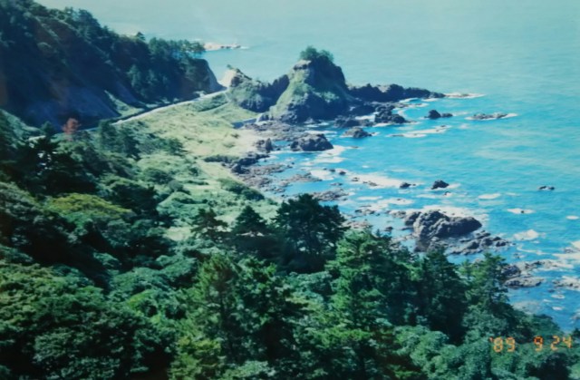
After passing through several tunnels on Route 8, the Hokuriku Expressway came into view on the right over the sea. This highway had just been completed the previous year, in 1988. With national highways and rail tunnels already existing inland, perhaps there was no space left to dig further, or maybe building over the sea was cheaper.
Either way, it became a rare example in Japan of a highway running over the ocean. The photo shows a side road near the national highway; half of it is a promenade. While the sheer cliffs rise over 300 meters from the sea elsewhere, here I think they’re only about 70 to 80 meters high. The weather remained the same; not only was the Noto Peninsula obscured, but even the sea was only faintly visible.
東京から再び日本海側へと向かったのは、先ず能登半島を目的地としたからです。以前から一度は行ってみたいと思っていました。糸魚川から新潟と京都を結ぶ国道8号線を走ります。
最初の見所は飛騨山脈がいきなり日本海に落ち込む断崖絶壁「親不知(おやしらず)」。明治になって国道と北陸本線が開通されるまで北陸道の最大の難所とされていました。それまで人々は断崖絶壁下の僅かばかりの砂浜を道として往来しており、時として荒波にさらわれる犠牲者も出ていました。
「押し寄せる荒波で親も子も互いにかまっていられない」それが地名の由来となっています。正式には「親不知、子不知」といわれ、糸魚川の次の青海(おうみ)駅と親不知駅間が「こしらず」、親不知駅と次の市振(いちぶり)駅間が「おやしらず」になります。距離にして14、5キロほどです。
全国的に親不知の地名が知られるようになったのは水上勉氏の小説「越後つついし親不知」によるところが大きいと思います。物語では親不知に程近い集落の人たちが描かれており、東京オリンピックが開催された1964年に東映が製作、今井正監督で映画化されています。成人指定のため当時中学生だった私は観ることが出来ませんでした。
「つついし」とは直江津と糸魚川の間にある海辺の町、筒石のことではないでしょうか。筒石駅は珍しいトンネル駅としても鉄道マニアに知られています。上下ホームとも改札から階段で300段近く、200mほど下ったところにあります。
8号線のトンネルをいくつか抜けると右手海上に北陸自動車道が見えてきました。この前年1988年に完成したばかりの高速道路です。すでに陸側に国道と鉄道のトンネルがあり、新たに掘るスペースがないのか、それとも海上を通した方が建設費がかからないのか、日本では珍しい海上を行く高速道路になっています。写真は国道近くの側道、半分が遊歩道です。断崖絶壁は海から300m以上ありますが、この場所で7~80mだと思います。相変わらずの天気で能登半島どころか海もボンヤリとしか見えません。

Immediately after Ichiburi, you enter Toyama Prefecture. You’ll drive through the plains along Toyama Bay, passing Kurobe, Uozu, and Namerikawa.
市振からすぐに富山県になります。黒部、魚津、滑川と富山湾沿いの平野部を走ります。
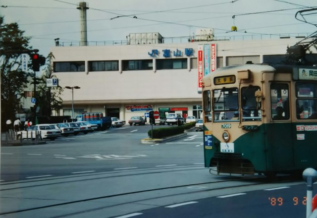
This photo was taken in front of Toyama Station. After this, I headed to Himi via Shinminato on National Route 160.
Finally, the long-awaited Noto Peninsula! But due to heavy rain, I ended up spending two nights in the waiting room at Himi Station. What a bummer?!
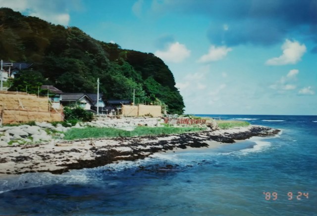
Entering Ishikawa Prefecture, I took National Route 249. From there, following Route 249 would take me all the way around the peninsula. That night, I camped at Kujukubayashi Park on the Uchiura Coast.
At Suzu, I left the national highway and headed toward Rokkosaki, the tip of the peninsula.
写真は富山駅前です。この後、新湊を経て国道160号線で氷見へ。いよいよ待望の能登半島ですが、大雨のため氷見駅の待合室で二晩過ごすことに、ナンテコッタイ?!。
石川県に入り、国道249号線へ。後は249号線を走れば半島をぐるり一周できます。この日は内浦海岸の九十九湾公園でテント泊。
珠洲(すず)で国道から外れ、半島の突端、禄剛崎(ろっこうさき)へと向かいます。

The photo shows Mitsuke Island near Ukai Station on the Noto Railway, just before Suzu. Also known as Battleship Island, its resemblance to a battleship is clearly visible when viewed head-on. The Noto Railway was discontinued after the Heisei era began in 1989.
Noto is a region of half-farming, half-fishing, and it’s currently the peak of the rice harvest season. While Ishikawa Prefecture is known as a rice-growing area, its terrain, exemplified by the Shiroyone Senmaida terraces near Wajima, features many terraced fields and small paddies. This makes finding space to dry the harvested rice a challenge. Therefore, rice drying racks called “hasa” are built high in multiple tiers using logs and bamboo to efficiently maximize space.
Can you see the rice drying racks in the photo, stacked high with golden rice stalks? Incidentally, Shiroyone Senmaida is said to have exactly 1,004 terraces.
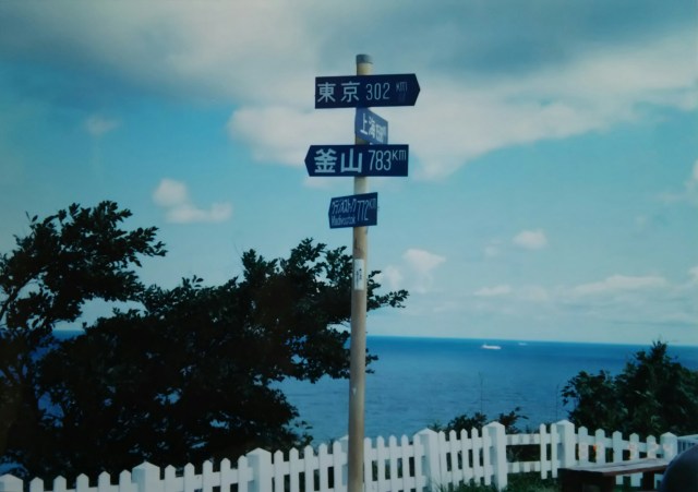
The next photo shows Rokkōsaki, overlooking the sea. Near the lighthouse stands a monument inscribed “The Center of the Japanese Archipelago.” Apparently, the Geospatial Information Authority of Japan determined the center of Japan lies off Toyama Bay, so Rokkōsaki, being the closest land point, was designated accordingly. The sign in the photo lists the distances to Tokyo, Shanghai, Busan, and Vladivostok, indicated by the arrows. This spot is also known as a vantage point where both the sunrise and sunset can be seen.
写真は珠洲の手前「のと鉄道」鵜飼駅近くの見付島。別名を軍艦島と呼ばれ、真正面から見ると軍艦の形をしているのがよくわかります。「のと鉄道」は平成になって廃線になっています。
能登は半農半漁、ちょうど稲刈りシーズン真っ盛りです。石川県は米どころとして知られていますが、輪島近郊の白米(しろよね)千枚田に代表されるようにその土地柄ゆえ棚田や小さな田んぼが多く、刈り取った稲を干す場所にも苦心します。そのため稲架(はさ)と呼ばれる稲干し場を丸太や竹で何段にも高く組み上げ、効率的にスペースを確保します。写真で高くまで黄金色の稲穂が干された稲架がわかりますか。ちなみに白米千枚田は本当に1,004枚あるそうです。
続いての写真は海を望む禄剛崎。灯台の近くに「日本列島ここが中心」のモニュメントがあります。なんでも国土地理院が日本の中心が富山湾沖にあるとしたとかで、ならば一番近い陸地の禄剛崎をということらしいです。写真の標識はそれぞれ矢印の先、東京、上海、釜山、ウラジオストクまでの距離を記しています。この地は朝日と夕日の両方が見られるポイントとしても知られています。

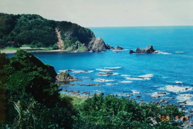
Perhaps because the weather had cleared, both the seashore and the surrounding greenery seemed to glow. Gone was the fierce, eerie image I’d seen in films as a child of Wajima’s traditional performing art, the Gojinjō Daiko drums pounded relentlessly in the darkness.
The Gojinjō Daiko drums originate from the villagers of Nafune, near Wajima. To drive off the invading Uesugi army, they wore masks over their faces, seaweed on their heads, and launched a surprise attack at night, beating their drums. It is said the strategy succeeded brilliantly, and the Uesugi army fled.
天気が回復したせいか、海辺も周りの緑も輝いて見えます。そこには私が子供の頃に映像で見た輪島の伝統芸能、暗闇の中でこれでもかと叩かれる御陣乗太鼓(ごじんじょだいこ)の激しくもおどろおどろしたしたイメージはありませんでした。
御陣乗太鼓は攻め入った上杉軍を追い払うために輪島近郊の名舟(なふね)の村人たちが顔に仮面、頭に海藻被り、夜中に太鼓を打ち鳴らしながら奇襲したことに由来しています。見事、作戦は成功して上杉軍は逃げ去ったといわれています。
