Happy New Year.
明けましておめでとうございます。

This is footage I captured on my phone from yesterday’s TV broadcast. Amid strong winds, the aerial filming crew hovered in place, waiting for the sun to rise. What a magnificent first sunrise.
Finally, this cycling journey blog begins its final leg: circling Taiwan. Please stick with me a little longer.
Day 4 since arriving in Taiwan, setting off to circle the island.
Even though it’s Sunday, the roads are flooded with cars and motorcycles as usual—truly a never-ending line. [Ugh. This is awful.] The worst exhaust fumes for cyclists. Many people even wear masks while riding their bikes.
At that time, the population had already exceeded 20 million. Though Taiwan is slightly smaller than Kyushu, its population is about 10 million higher. Moreover, the Central Mountain Range, steeper than Kyushu’s mountains, runs north to south, limiting the plains to only the western and eastern parts. You can imagine how densely the population is concentrated in those plains.
Since I’d been heading south on the main highway all the way from Taipei, the cityscape never ended. [This is going to make finding a place to camp tough.] That night, I veered off the main road and camped on a riverside path. Even in late October, it gets dark by 6 PM.
The next day, I struggled again to find a place to camp. Finally settling under a bridge, I was woken in the middle of the night by wild dogs barking at me as if I were an intruder. Come to think of it, there were many stray dogs, and the streets weren’t exactly clean, but everyone I met was bright and kind. Work also seemed to proceed at a leisurely (?) pace, going on late into the night.
Continuing south through Taichung, Changhua, and Chiayi, I’ve reached near the Tropic of Cancer. Even in November, I’m still riding daily in a T-shirt and shorts. Sugarcane and banana fields dominate the landscape around me.
While Taiwan’s industrial production surpassed agricultural production in the 1960s, agriculture remains strong today. Over a quarter of the land is still farmland, and the island exports many agricultural products, rice being the main one.
これは昨日のテレビ中継の映像をスマホで撮ったものです。強風の中、空撮のために撮影スタッフはホバリングしながら太陽が上るのを待機していました。素晴らしい初日の出です。
いよいよこの自転車旅のブログも最後の台湾一周が始まります。もうしばらくお付き合い下さい。
台湾到着から4日目、台湾一周へ出発です。
日曜日だというのに道路は例によって車とバイクの洪水、数珠つなぎとはよく言ったもんです。[うへーッ。こりゃ、ひどいな]自転車乗りにとって最悪な排気ガスです。マスクをしてバイクにのっている人も大勢います。
当時、人口はすでに2,000万人超、台湾は九州より一回り小さいながらも人口は1,000万人ほど上回っています。しかも南北に九州の山地より険しい中央山脈が走り、平野部は西部と東部の一部に限られています。いかに人口が平野部に集中しているか想像できます。
台北からずっと幹線道路を南下したこともあり街並みが途切れることがありませんでした。[こりゃ、野宿の場所探しに苦労するな]この日は幹線道路を外れ、川べりのあぜ道に野宿。10月末でも6時ともなればあたりは暗くなります。
翌日も野宿の場所には苦労しました。やっと見つけた橋の下、私は侵入者なのか夜中に野犬に吠えたてられ起こされる始末です。そういえば野良犬が多く、街並みも決して綺麗とはいい難いのですが、出会う皆さん明るく親切に接してくれます。仕事も夜遅くまでノンビリ(?)マイペースでやっています。
台中(タイヂョン)、彰下(ヂャンホア)、嘉義(ジャーイー)と南下を続け北回帰線近くまで来ました。11月に入っても連日Tシャツ、短パンで走っています。周囲にはサトウキビ畑とバナナ畑が目立ちます。
台湾は1960年代に入り、工業生産が農業生産を上回りましたが、今でも国土の4分の1以上が耕地というように農業も盛んで米を始め多くの農産品を輸出しています。
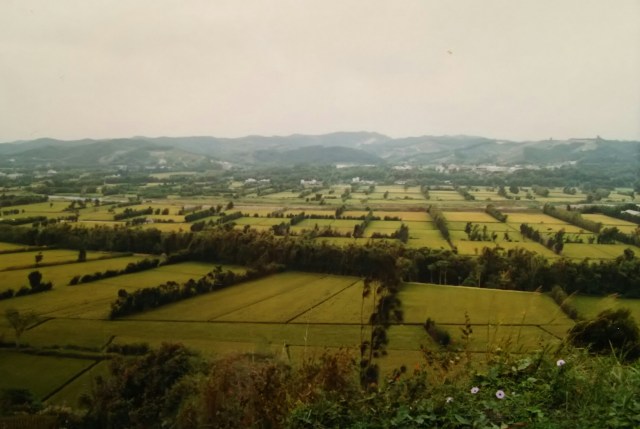
The rice fields stretch out like this.
The next day, I changed course eastward and headed straight up Route 18 toward Alishan. I covered 60 kilometers and climbed 2,200 meters in elevation.
こんな感じで稲田が広がっています。
翌日から進路を東へ変え、ひたすら18号線を上り阿里山を目指します。走行距離60キロで標高差2,200mを上ります。
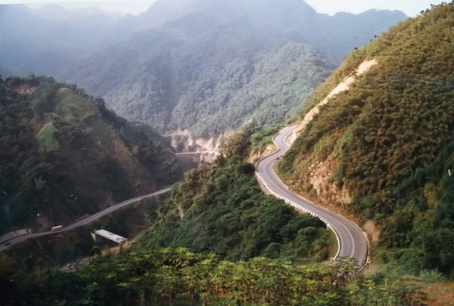
After passing through Chiayi City, Route 18 continues along mountain roads like this. Alishan is the collective name for the surrounding mountains, forming the Alishan Forest Recreation Area, one of Taiwan’s premier tourist destinations.
That night, I camped as planned in a village just before Alishan. I figured camping within the recreation area itself would likely be prohibited. Even so, the elevation seemed to be around 1,500 meters. I could hear the sound of drums from the village—perhaps a festival?—but the long climb had taken its toll on my body, and before I knew it, I had fallen asleep.
[Brrr, it’s cold!] The morning chill woke me up, probably due to the higher altitude.
18号線は嘉義の街を抜けると、その先はずっとこんな山道になります。阿里山とは周辺の山々の総称で「阿里山森林遊楽区」として台湾有数の観光名所になっています。
この日は阿里山手前の集落で予定通りの野宿。遊楽区内での野宿は禁止されているだろうとの判断です。それでも標高は1,500mぐらいありそうです。お祭りなのでしょうか、村から太鼓の音が聞こえていましたが、久々の上りが体にこたえたとみえ、いつの間にか眠ってしまいました。
[うへーッ、寒いわ]標高が上がったせいか朝の寒さで目が覚めました。
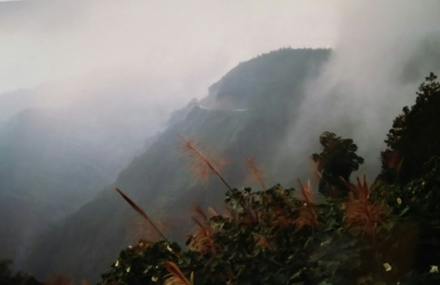
Alishan is famous for its sea of clouds, but this is fog. I climb higher through the fog from morning onward.
One of Alishan’s famous “Five Wonders” is the Alishan Forest Railway. It’s a mountain railway stretching just over 70 kilometers from Chiayi Station at 30 meters above sea level to Zhaoping Station at 2,247 meters. Constructed during the Japanese colonial period in 1914, designed by Japanese engineers and completed after nearly a decade of construction, it initially opened as a steam locomotive for transporting Taiwan cypress timber. Passenger service began a few years later.
This forest railway allows passengers to observe the changing vegetation of tropical, subtropical, and temperate forests in a single ride. Utilizing its narrow gauge—30 centimeters narrower than standard track—the railway employs tight loops and switchbacks to steadily climb upward, attracting railway enthusiasts not only from Taiwan but worldwide.
The tracks occasionally appeared beside the road I was driving on, but perhaps due to the limited number of trains, I never saw one running alongside me. The remaining four of the “Five Wonders” are sunrise, sea of clouds, evening glow, and sacred trees.
阿里山は雲海が有名ですが、これは霧です。朝から霧の中をさらに上ります。
阿里山の名物「五奇(五大奇観)」の一つに「阿里山森林鉄道」があります。海抜30mの嘉義駅を始発として2,247mの沼平駅までの70キロちょいの登山鉄道です。日本統治時代の1914年、日本人の設計により10年近くの工事を経て、当初は台湾檜を搬出する林業用の蒸気機関として開通しました。その数年後に人も乗車できるようになります。
この森林鉄道は一回の乗車で熱帯林、亜熱帯林、温帯林と植生の変化を眺めることができます。普通の軌道より30センチ狭い線路幅を活かした小回りのループやスイッチバックを駆使してグングン上る姿に、台湾のみならず多くの鉄道ファンがいます。
私が上る道路脇にその線路が時々現れるのですが、運行本数が少ないのか並走することはありませんでした。「五奇」の残る四つは日の出、雲海、夕霞、神木をいいます。
